This is the old United Nations University website. Visit the new site at http://unu.edu
The agro-forestry development plan and practices of picop
Arcadio G. Matela
Origin of the Project
The Paper Industries Corporation of the Philippines (PICOP) is an integrated wood-based industry which obtains most of its supplies of raw material from its own concessions. To obtain further sources of supply for growth and expansion it has embarked on an agro-forestry programme involving landowners whose land is outside PlCOP's own concessions.
Planned agro-forestry began in the Philippines in 1967 through the initiative of Forester Nicholas P. Lansigan, then PICOP Assistant Vice-President for Forestry, in setting up the PICOP programmer. This is essentially a self-help programme for the improvement of the socio-economic welfare of the people living near PlCOP's concessions, and is especially designed to develop supplementary sources of pulpwood for the pulp and paper mill at the town of Bislig, province of Surigao del Sur, in the eastern part of Mindanao.
Planting began in a very modest way in 1968 with a few sceptical landowners who were reluctant to undertake tree farming. The writer was engaged as an Agro-Forestry Consultant by the corporation in mid-1969, when the scheme began to gain momentum. Progress accelerated considerably in 1972, when the farmers obtained their first earnings from early thinkings, and realized the great potential of agro-forestry for improving their living standards.
In 1972 also, the Development Bank of the Philippines (DBP) became interested in the project, after a study had been submitted to it by PICOP and bank officials had visited the twenty-two demonstration farms in the Bislig area. In view of the praiseworthy objectives of the project they agreed to provide financing for the participating farmers. Later the World Bank, recognizing that the project was a viable and profitable one, took part in the financing through the DBP. It was considered that the PICOP plan would be a good model suitable for duplication not only in the Philippines but in other developing countries. A condition of the loan to farmers was the inclusion of a pulpwood marketing agreement between the farmers and PICOP.
Progress
By December 1980, 3,800 farmers were participating in the PICOP project, as compared with 22 in 1969. By that date 11.3 million trees of Albizia falcataria had been planted at a normal spacing of 4 metres by 4 metres on 22,600 hectares. Of the participating farmers, 44 per cent had availed themselves of the finance provided by DBP and the World Bank, and 56 per cent used their own resources.
With an average yield on an eight-year rotation of 250 cubic metres of pulpwood per hectare, the potential pulpwood supply will be about 760.000 cubic metres per annum. At 72.75 pesos per cubic metre, this will provide the farmers with a total of about 51.4 million pesos year (1 U.S.$ = 14 pesos).
Actually, between 1975 and 1979, before the plantations were fully mature, PICOP had already bought 660,579 cubic metres of pulpwood from farmers, valued at 37,963,500 pesos. During the first half of 1980, 119,932 cubic metres were sold to PICOP for 13,248,600 pesos.
Details of the Agro-forestry Development Plan
Under the "Agro-forestry Development Plan for Farmers" PICOP staff not only guide the farmers in growing fastgrowing trees for pulpwood, but also give advice on growing food-crops and on raising pigs, poultry, cattle and fish. The general objective of the plan is to assist in the socio-economic uplift of the people, particularly the small landowner-farmers, as well as the members of their families. through a self-help agro-forestry project. The specific objectives are (a) to assist the farmers to increase their production of cereals, vegetables, fruits, meat and fish, and (b) to assist the farmers to grow fast-growing pulpwood on their privately owned land for sale to the PICOP pulp and paper mill.
The concept of the project is to develop the land intensively, by devoting 20 per cent of the most suitable land to production of farm crops and livestock, and using the remaining 80 per cent of poorer land for tree farming. Intercropping of annual food crops, such as rice. maize, root crops, vine crops, and vegetables, between the young trees, possibly until they reach the age of three years, is advisable. It provides the farmer and his family with additional food and cash income, and helps in weeding and maintenance of the tree plantations.
Under the loan assistance programme of the DBP and the World Bank, landowner-farmers who own from five to fifty hectares of land, outside the PICOP concession, but within 100 km distance by road from the PICOP mill, can obtain loans for the development of their land, both for food and pulpwood production.
Three methods of agro-forestry farm management are recognized. The first is used where there is existing good second-growth forest. Here on ten hectares, two hectares will be used for food-crops and livestock, while the remaining eight hectares will be managed for pulpwood by harvesting the trees which reach pulpwood size each year, and allowing the smaller ones to continue to grow. That is, a form of selection system will be practiced.
In the second case, second-growth forest is converted into cropland and tree plantation. As before, on a ten-hectare plot, two hectares are used for foodcrop and livestock production, and of the remaining eight hectares, one hectare is cleared of secondary forest and artificially planted with fast-growing trees each year. In the third case when the land is bare of trees, two hectares are planted with foodcrops, etc., and one hectare is planted with fastgrowing species each year.
Conclusions
The PICOP agro-forestry programme has shown that the private sector can be an effective partner of the government in making the hills and mountains "greener" by planting economic trees. Agro-forestry not only contributes to raising the socio-economic standards of the people, but is also an effective means of forest conservation, forest protection, maximum utilization of land, improving public relations, community development, and creation of employment.
Employment is created in preparation of land for food and wood-pulp production; in planting, maintaining, harvesting and marketing trees; and in producing, harvesting and marketing farm crops and livestock. The results are: increased family income, better education, improved health, and more active family participation in the affairs of the community and the government.
At present, in addition to the 3,800 participant farmers, 11,400 labourers, 65 truck drivers and 65 truck helpers are employed as a result of the project, under the management of the farmers themselves, and on their payroll. Thus a relatively small-scale project has benefited 15,330 people plus their dependents. This is a great step forward in the fight against poverty.
Agro-forestry as practiced in PICOP is simple, practical, economical, profitable and duplicatable. It is hoped that such schemes will, in fact, be duplicated on a wide scale.
Appendix 1. Economics of Agro-forestry Tree Farming Project
| Pesos | |
| I. Gross income from the average harvest of 250 m³ of Albizia falcataria per hectare | |
| in the ninth year, and selling at the rate of 72.75 pesos m³ | 18,187.50 |
| II. Costs | |
| Establishment costs | |
| 1. Land clearing and preparation | 300.00 |
| 2. Purchase and handling of seedlings, lining, staking, holing, planting and replanting | 755.00 |
| 3. Weeding, cultivation and fertilization | 645.00 |
| Sub-total | 1,700.00 |
| Harvesting
and transport 1. Harvesting and transporting to roadside, debarking and cutting to convenient length of 2.5 metres at the |
|
| rate of 32.50 pesos per m³ based on 250 m³ harvest per hectare | 8,125.00 |
| 2. Hauling from roadside to millsite (subsidized by PICOP as far as 100 km road distance from millsite) | |
| Sub-total | 8,125.00 |
| Interest and
taxes 1. Interest on investment of 1,700.00 pesos upon harvest on the ninth year at the rate of 12 per cent |
|
| (simple) per annum | 1,632.00 |
| 2. Land tax and special educational fund for eight years at the rate of 2 per cent yearly of the assessed value | |
| of the land, 560.00 pesos per hectare | 569.60 |
| 3. Contingencies including other government levies | 2,000.00 |
| Sub-total | 4,201.60 |
| Total cost per hectare | 14,026.00 |
| Net income per hectare at the ninth yeara | 4,160.90 |
a Not included is the labour-income of the working Agro-forestry farmer and/or the members of his family, in such activities as land clearing and preparation, lining. staking. holing, planting and replanting. weeding, cultivation, fertilization, harvesting, hauling to roadside, debarking, and cutting of pulpwood to convenient length of 2 5 m.
Appendix 11. The Guiding Principles in the Implementation of the PICOP Agro-forestry Programme for the Socio-economic Uplift of the People or How PICOP Transfers Agro-forestry Technology to the Farmers
1. Go to the people.
2. Live among them.
3. Love them.
4. Learn from them.
5. Serve them.
6. Plan with them.
7. Start with what they know.
8. Build on what they have.
9. Learn by doing.
10. Teach by showing.
11. Not piecemeal but integrated approach.
12. Not showcase but pattern.
13. Not relief but release.
14. Mass education through mass participation.
The guideline is, "the outsider can help, but the insider must do the work." What is needed is "not relief, but release" of the latent or dormant or hidden potential of the farmer-participants. They need a challenge to do good work, but with proper guidance to do so. This is why PICOP agro-forestry is an effective self-help project for the uplift of the people.
Appendix III. PICOP Incentives for Agro-forestry Farming
1. Assistance in locating and/or acquiring vacant public agricultural lands.
2. Technical advice in determining which portions of the land are good for food cropping and livestock farming and which for tree growing.
3. Technical advice on the preparation of land for planting, methods of planting, maintenance and management of tree farms and marketing of pulpwood trees.
4. Technical advice on the methods of planting, cultivating, processing and marketing of food crops, as well as on the raising and marketing of livestock.
5. Assistance in obtaining loans from government financing institution for tree farming and for food production.
6. Providing Albizia falcataria seedlings the cost of which is payable after the pulpwood is harvested, without interest.
Agriculture, fuelwood, and conservation farming in the atzera range, lae, Papua New Guinea
Beka F. Siki
The Atzera Range is an extensive, steeply sloping hill system adjacent to Lae, the second largest urban centre and most important industrial town of Papua-New Guinea. It has been greatly affected by migrants coming to the city from rural areas, who, when unable to obtain employment, have established squatter settlements with gardens for food, often on steeply sloping land, and have also felled many trees for fuel and house-building. These activities have resulted in excessive soil erosion and runoff, causing flood damage to roads, bridges and the sewage system of the city. Long-term effects are the loss of the capability of the land to be of use to the inhabitants, and deterioration of the ecosystem.
A team from the Australian National University, sponsored by UNESCO/UNEP, compiled a comprehensive plan for the conservation of the range. and the Government of Papua New Guinea allocated funds for implementation of this plan over a six-year period, beginning in 1979. The administration of the project is vested in the Lae City Council, with technical advice from the Atzera Range Committee. This committee is made up of representatives of the relevant government departments, universities, city and provincial governments, and other bodies.
The programme includes the following activities:
1. The establishment of fuelwood plantations on moderately sloping areas within the hills;
2. The establishment of intensive food gardens and fuelwood cropping on the flat or gently sloping areas;
3. The ecological rehabilitation and ecological conservation of steep hillsides, eroded river and creek banks, and other degenerated areas;
4. The establishing of a distribution network for firewood and charcoal distribution.
The main objectives of this programme are to:
1. Control the environment and improve ecological stability;
2. Provide a long-term security for firewood and charcoal supply;
3. Increase food supply to urban areas;
4. Improve the nutritional status of the settlers.
Fuelwood Plantations
Firewood is the main source of energy for the pert-urban areas of Lae, and so it was planned to plant a substantial area of the less steeply sloping hill slopes with quickgrowing, easily coppiced trees producing firewood which burns reasonably well. Ability to fix nitrogen and improve the soil were additional properties to be considered. The species eventually used were Leucaena leucocephala (El Salvador Providence), Acacia auricularae form is, Eucalyptus torelliana. E. tereticornis, E. deglupta. Tectona grandis, Casuarina equisetifolia and C. oligodon. This list may be changed as the result of experience, and the availability of planting material of other species.
The spacing between the trees is 3 metres by 3 metres, and food-crops are allowed to be cultivated between them until the canopy closes, a period of at least six months. After this period the gardeners move to new planting areas. The rotation for Leucaena is two and a half to three years, and for other species four to seven years, after which the trees are felled and food crops may again be cultivated. At present 5 to 10 hectares are being planted at a time on a rotational basis, with a total of 62 hectares by June 1981.
This is a modification of the traditional shifting cultivation to which the cultivators are accustomed, with a reduction of the fallow period due to the replacement of natural forest by planted trees, while the length of the food-producing period is maintained. A system of extensive land use has been changed to a system of continuous land use.
Intensive Food Gardens Combined with Fuelwood
This method is used on lands with slopes up to 30°. Leucaena is planted in rows 3 to 4 metres apart, with 1 metre between the plants in the rows. Each farm has an area of 2 hectares divided into 5 plots of 0.4 hectares each, and the individual plots are subdivided into family units, the size of each family plot depending on the numbers of families who previously cultivated in the area.
Food crops are grown between the trees for at least six months, or until the shade of the trees becomes too heavy for crop growth. The cultivators then move to the other plots in succession, until the first plot is three years old and the fuelwood can be harvested, when the cycle begins again. In the two oldest farms, first planted in 1979, the fifth planting was due to be made in January 1982, and the first fuel crop harvested in July 1982, when a new cycle would begin.
The objectives of the system were to demonstrate the production of traditional food crops between rows of Leucaena; to demonstrate contour-mounding, incorporating the use of compost; to observe how traditional subsistence gardeners adapted to a new farming system; to demonstrate controlled land use, conservation, and the maintenance of soil fertility; to improve food and firewood production; and to serve as a basic model for extension to other areas.
As more families move out of their gardens on sensitive sites more land will be needed for this type of farming, and additional sites for this are being acquired.
Rehabilitation of Degenerated Areas
These include eroded sites on creek-banks, hillsides and peaks, foot-trails, landslips, areas infested with kunai (Imperata) and disused gardens.
In these areas deep-rooting trees and shrubs are being planted, including in addition to fuelwood and timber species, some plants which produce food and other traditional products such as medicines and fibre. A list of species suitable for different ecological zones, and the products produced from them has been prepared, including details on propagation techniques.
Ecological Conservation
Conservation reserves are being established to protect vulnerable places such as land close to streams, creeks and water courses, steep slopes, ridge crests and cliffs. Protection is also given to remaining stands of undisturbed forests and individual reproductively mature trees, and to endangered plant and animal species. The objectives are to arrest degradation, to sustain diversity of ecological relationships (including human), and to help to safeguard self-regulating ecological processes such as nutrient recycling and population stability.
Network for Distribution of Firewood and Charcoal
A beginning has been made in building small firewood sheds in the main settlement areas round the foot of the hills, which will later be supplied from one or two central holding depots. These sheds will be eventually stocked with the produce of the new plantations, but until this is available offcuts and wood waste from a local sawmill are being used. Between 1979 and June 1981, 450 tonnes of firewood was distributed through the sheds; demand has been high, but there are some transport problems.
Experiments and Trials
Experiments have been laid down on spacing of different fuelwood trees, and on the interaction between Leucaena and sweet potato (Ipomaea batatas) when planted together. Research is taking place on methods and strategies for soil conservation, and surveys are being made on nutrition and food-crop production.
Composting and Community Food Gardens
The Lae City Council has a scheme for production of compost from garden refuse, brewers' grains, chicken and cow manure, and sawdust, for use in the Atzera Hills. Present production is 2,000 tonnes per year, with plans to increase this to 10,000 tonnes.
The council has also established twenty hectares of community food gardens on wasteland in and near the city, and people who cannot be given garden lands on ecologically suitable sites in the hills are encouraged to cultivate there.
Conclusion
The Atzera Range Conservation Programme is based on the use of agro-forestry techniques, and sound ecological planning. More knowledge of the interactions between soils, plants, climate and socio-economic factors is however needed to permit further refinement and improvement of the systems.
Bibliography
Harris, J.A. 1979. "The Atzera Project: Ecological Management of the Atzera Range adjoining Lae, Papua New Guinea. An Initial Proposal." Technical Paper No. 4 of the Papua New Guinea Human Ecology Project (PNGHEP).
Newcombe, N.K. and T. Pohai. The Papua New Guinea Human Biology Programme, "Lee and its Hinterland". Man and the Biosphere Project 11, Integrated Ecological Studies of Human Settlements. UNESCO/UNEP Centre for Resource and Environment Studies ANU, Canberra.
Siki, B.F. and V. Dube. 1979. "Food Production in the Lae City Area." Paper presented at the Workshop on Urban Food Supply; Waigani Seminar, 24 28 September 1979.
Problems of agro-forestry in land-use planning
T.C. Sheng
Introduction
As a science agro-forestry is relatively new, although in . practice it has been used in some countries for centuries. The definition of agro-forestry covers a wide range of activities including at least agri-silviculture, silvopasture, agro-silvopasture and multipurpose forest production (King 1980). As agro-forestry is a new and many-sided discipline it gives rise to certain problems in land-use planning and policy-making. This paper concentrates on discussion of the following basic problems: What kind of land should best be used for agro-forestry? Is agro-forestry alone sufficiently effective in protecting the environment? What problems are faced in planning agro-forestry, including strategies, farmers' participation and government inputs?
Suitability of Land for Agro-forestry
Classification Criteria
In land-use planning, the first task encountered by the planners is to formulate the criteria by which land is classified for optimum use. The concept of proper or rational land use cannot be realized unless certain scientific and practical criteria are available for classifying each piece of land. Criteria vary from country to country. However they are mostly based upon the physical conditions of the land together with the socio-economic conditions of the particular country in which they are to be applied.
Are such criteria necessary in classifying land as suitable for agro-forestry? The answer must be in the affirmative. During the Latin America Soil Conservation and Soil Management Workshop in Peru, this subject was discussed and it was recommended that land-use maps of the region should include potential zones for agro-forestry.
Although the activities included in agro-forestry are very diverse they cannot be applied on all types of land by all people. On the other hand, it is too conservative to think that agro-forestry should be mainly confined to areas under shifting cultivation or within the boundaries of government forest reserves.
If we do agree that certain areas should best be earmarked for agro-forestry, for the benefit of the people and the nation, then the next question is: Do criteria already exist for classifying land as suitable for agro-forestry?
These criteria. as in all other systems of land capability or land suitability classification, should include the factors as in Table 1.
TABLE 1
| Site | Land Physical Properties |
Socio-economic Conditions |
| Elevation | Soils | Present and traditional |
| Climate | Slope | land use |
| Erosion | Population pressure, | |
| labour and employment | ||
| Other macro | ||
| socio-economic | ||
| conditions |
The classification and use of land should serve the people and the country for generations to come, and not aim only at short-term benefits. In other words, all land should be used within the limits of its capability and in accordance with the principles of resource conservation.
Examples
Two examples are briefly introduced here: one from northern Thailand and the other from Jamaica. In both, the criteria are quite straightforward.
Narthern Thailand The criteria employed in Northern Thailand for classifying land within a 43,000 hectare watershed as suitable for agro-forestry were as follows:
Slope:
From 19° to 27° (35 to 50 per cent).
Soils:
Depth 50 cm and over; no permanent use limits such as the soil
being too wet or too stony.
Erosion:
No severe erosion such as dissection by gullies.
The rainfall in the watershed averages about 1,500 mm and the elevation ranges from 300 m to 1,700 m. There is no need to spell out the socio-economic conditions of northern Thailand as several UNU mettings have been held at Chiangmai in recent years and many papers have discussed these conditions in great detail. However, the watershed is essentially a forest watershed and the main objective of the classification into land suitable for various types of use, including agro-forestry, was to rationalize land use and promote integrated development. The final result showed that about 18 per cent of area of the watershed should be designated for tree crops and agro-forestry.
Jamaica
Jamaica is a small Caribbean island in the tropics. Of its
total area of 11,400 km², 75 per cent is rugged. Most small
farmers live in steep watersheds.
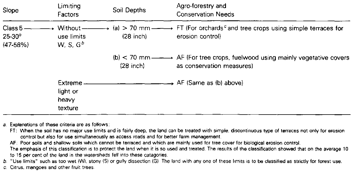
A land capability classification scheme including tree crops and agro-forestry has been introduced in Jamaica since the 1970s (Sheng 1972). At present, the Government of Jamaica. with the support of FAO, UNDP and the Norwegian Government. is classifying six municipal watersheds around the capital of Kingston for a bankable project. The criteria for land for agro-forestry are given in Appendix I.
Justification
In considering the above examples. people may wonder why agro-forestry should be confined to slopes or rather to steep slopes. The reasons are many. From the national planning point of view, flatter lands and good lands should be used intensively for producing agricultural crops, either for export or for domestic use. From the farmer's standpoint, the same principle applies. Better soil and gentle slopes are used for vegetables or staple food crops while steep slopes should be for tree crops or trees. Since the world population will increase to 7 billion by the beginning of the next century and more marginal lands with steep slopes will be brought into cultivation (Biswas and Biswas 1978, Pimental et al. 1976) it is rather a luxury to use good, gently sloping land for agro-forestry or tree crops. According to a seminar report, 50 per cent of the Andean, Central American and Caribbean areas consists of steep slopes.
From the standpoint of resources conservation, steep slopes should be put under permanent or semi-permanent vegetative cover. If agro-forestry should occupy gentle lands and the cultivation of annual crops should shift on to steep slopes, this kind of land use would without any doubt result in tremendous problems in erosion, management and costs.
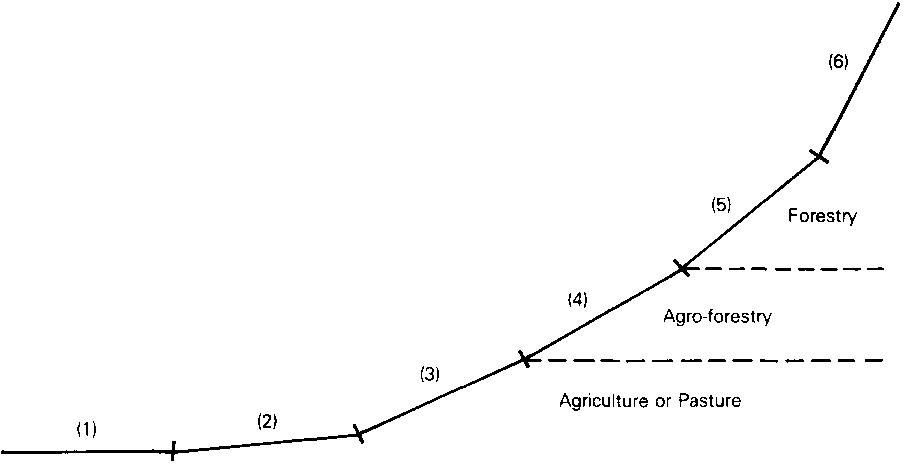
Figure 1 is a profile showing the zone suitable for agroforestry in relation to other uses. This is based on experience from hilly developing countries. In large and flat countries, agro-forestry seems to be better suited to marginal landa.
Effectiveness for Environment Protection
On Erosion Control
All agro-forestry systems should conserve and improve the sites (King 1980). From the point of view of erosion control an ideal agro-forestry system should provide a quick, complete and multi-storey vegetative cover to protect the land from rain-splash erosion and minimize soil detachment. Otherwise agro-forestry cannot be regarded as wise or proper land use, especially on steep slopes in humid tropics.
In the United States and several Central African countries, the tolerable soil loss rates are from 2.5 to 12.5 tonnes per hectare year (Hudson 1971). When the erosion rate of a particular field is known, every effort has to be made to reduce the soil loss to tolerable limits by applying various conservation treatments. Much soil conservation research in the tropics and sub-tropics has shown that the farmers' traditional methods of cultivation on moderate slopes produce an average loss of 150 tonnes of dry soil per ha per year (Sheng 1972). Even with the most intensive form of conservation treatment such as bench terraces the soil loss can at best be reduced by 90 to 95 per cent, or to 10 to 15 tonnes per hectare per year (Sheng 1981).
FIG 1: Hypothetic Profile Showing Relative Sites of Land Use
(1 ) Flat lands: For agricultural crops.
(2) Gentle slopes: Up to 7° (12 %). For agricultural crops;
planted with simple agronomic conservation measures, i.e. contour
and close planting, strip cropping, vegetative barriers, etc.
(3) Moderate slopes: 7° to 25° (12-47%). For agricultural
crops; planted on various terracing systems, i.e. hillside
ditches, intermittent terraces, bench terraces, etc.
(4) Steep slopes: 25°-30° (47-58%). For agro-forestry and
orchard crops; planted with individual basins, orchard terraces
and/or the establishment of proper vegetative cover for erosion
control.
(5) Very steep slopes: 30°-40° (58-84%). For forestry.
(6) Cliff and non-operable slopes: 40° (84%) and over.
Protection forest or recreation.
N.B. The slopes suitable for each category of land use may vary
according to the erodibility of soils on different sites. The
important thing is the relative position of the various types of
land use along the profile. Category (1), (2) and (3) land is to
be classified for use as pasture when the soils are shallow or
have other use limits.
How effective are various agro-forestry systems in terms of erosion control? Can the vegetative cover of the agroforestry system be developed to fully protect the soil? What will be the best combinations of trees and crops in space and time to minimize erosion and increase production? More research is surely needed to find out the answers.
In many tropical countries, fast-growing trees or shrubs are now being introduced by planting them across the slopes leaving alternative belts for crop cultivation. Problems of shading crops and erosion of the cultivated belts are still unsolved.
For effective erosion control, agro-forestry probably needs to be supplemented with simple soil conservation measures such as discontinuous types of terraces, mulching, individual basins, etc., wherever possible.
On Water Conservation and Others
The results from many experimental catchments in various parts of the world show that trees generally use more water than agricultural crops (Hewlett 1971; Pereira 1981). They extract moisture from considerable soil depths which the roots of ordinary crops cannot reach.
Reforestation with some pine species has been proved to reduce water yields from given areas or from whole watersheds (Douglass 1974; Kunkle 1975; Reigner 1970). Certain fast-growing tree species may have even more adverse effects on water resources. For instance, some species of Eucalyptus have been reported as drying up springs and depressing ground water levels. Yet Eucalyptus has been used in many countries as one of the major tree species in agro-forestry systems.
In municipal watersheds for domestic water supply, or in the source areas for irrigation water, the introduction of fastgrowing and water-loving tree species may not be entirely desirable.
There may be other adverse effects of certain tree species. Behmel and Neumann (1981) mentioned that in Rwanda certain tree species are not used for inter-cropping because of emission of plant-toxic substances (allelopathy). Many foresters in Taiwan believe that teak (Tectona grandis) has adverse effects on the site. In El Salvador, an experiment showed that teak plantations with no undergrowth lost between 64 and 82 tonnes of soils per hectare per year (Michaelsen 1975). Tree species should therefore be selected with great care.
The competition for light, moisture and nutrients between trees and crops interplanted between them is also an important subject for urgent study.
Problems of Development
Planning Strategies
In developing agro-forestry in a country, some difficult management problems will arise at the planning stage. The following are only a few of the obvious ones:
- What is the target group for which such activity is planned? Is it subsistence farmers aiming at self-sufficiency or progressive farmers involved in marketing and commercialization? In commercial farming, the diverse nature of the products, harvested in relative small quantities and at different times, will surely create difficulties in handling, storing, transportation, marketing and processing.
- What level of management and production is expected from those farmers who practice agro-forestry? Since the system can sometimes be complicated, can we expect the small and illiterate farmers to invest their labour, materials and other inputs at the correct time, and to maintain the system properly. If the level of management, and hence of production, is low, the programme is unlikely to attract financial support nationally or internationally.
- What kind of implementation period or planning templated, or is agro-forestry to be permanent or transitional? Many such activities in forest reserves are transitional. In these the ultimate goal is usually reforestation. Outside forest reserves, this type of mixed land use is often semi-permanent. Weaver (1979) has pointed out that the system is not a substitute for intensive agriculture or forestry. When the economy of a country is advancing, areas under agro-forestry will probably be either left to forest or be developed into commercial crop lands or orchards depending on the owner and the site. Many examples of this can be seen in advanced developing countries and in municipal watersheds. The traditional tendency of agro-forestry gives rise to an element of uncertainty to policy-makers and land-use planners.
Farmers' Participation
Probably this is one of the most crucial problems in developing agro-forestry in any country.
On public lands and in forest reserves farmers are to some extent prepared to accept the taungya system, the degree of acceptance being dependent on how the forest authorities handle the case. However in northern Thailand, as in central Taiwan, this acceptance has been limited. The problem seems to lie with the land-use history of the site. A new area of afforestation in which farmers are invited to practice taungya will cause no problems, but planting old cultivated fields with trees will not be welcomed by the squatters. Recent solutions to the squatter problem in these countries rely mainly on the declassification of forest lands, and re-allocation of gentle slopes within the reserves for cultivation by the former squatters or on setting up forest villages.
To bring trees or tree crops into private cultivated fields is much more difficult. For subsistence farmers, this means reduction of their traditional cropping areas or delay in obtaining income from their procedure. For progressive farmers, planting trees may mean adding obstacles to their farming, especially under mechanization.
To attract more farmers to agro-forestry we need to look at it from their standpoint to see whether the systems to be introduced are acceptable. If they are not, we need to modify them or derive new ones to suit the local conditions. Farmers' participation cannot be disregarded if agroforestry is to succeed.
Incentives and Extension Needs
Development of agro-forestry needs higher inputs in incentives and extension work than, say, soil conservation or cropping programmed, for the simple reason that trees or tree crops require more years to yield returns and the techniques involved are rather complicated.
In Jamaica, for instance an intensive ongoing soil conservation programme in which farmers are given 75 per cent of the land treatment cost as an incentive has not attracted the participation of too many farmers. The ratio of extension officers to farmers is 1: 200 which is very high by any standard.
Land treatment such as bench terracing with top-soil preservation and proper management can yield higher crop production in the same year. As an example, in Jamaica, at the soil conservation demonstration centre at Smithfield, yam (Dioscorea spp.) production was doubled on the newly constructed terraces in the year of construction and tripled in the second year and onwards. When establishing trees or tree crops farmers have to wait for at least four or five years to get returns. To compensate for the land occupied by trees, and the much delayed income, greater incentives will be needed.
Extension of agro-forestry work not only needs concentrated intensive programmed, but also requires many extension officers well equipped with knowledge of agriculture, forestry, horticulture, pasture, etc. There may be a problem in finding and training such personnel.
Final Remarks
If agro-forestry is used only as a means of solving the problems of shifting cultivation or squatting on government lands, its implementation is usually less difficult. If, on the other hand, it is to be developed as a permanent land-use pattern on private lands, the problems are considerable.
The queries raised in this paper are a challenge to all of us, whether land-use planners, policy-makers, conservationists, foresters or agronomists.
Only by having more experiments, field trials and demonstrations, and through a realistic grass-root approach can this new system of agro-forestry be properly established and developed to meet the needs of both the farmers and the nation.
References
Behmel, F. and 1. Neumann. 1981. "An Example of Agro-forestry in Tropical Mountain Areas." Paper presented to the Workshop on Agro-forestry in the African Humid Tropics. Ibadan, Nigeria, 27 April to 1 May.
Biswas, M.R. and A.K. Biswas. 1978. "Loss of Productive Soil." Ecologist Quarter/y. Autumn.
Douglass, J.E. 1974. "Watershed Values." Journal of Forestry October, 1974
Hewlett, J.D. 1971. "Comments on the Catchment Experiment to Determine Vegetal Effects on Water Yield." Water Resource Bulletin, 7 (2).
Hudson, N. 1971. Soil Conservation. B.T. Batsford Limited, London.
King, K.F.S. 1980. "Multiple-use Research." Keynote Adress. IUFRO/MAB Conference: Research on Multiple Use of Forest Resource, Flagstaff, Arizona, 18-23 May. USDA Forest Service General Technical Report W0-25.
Kunkle, S.H. 1975. An Introduction to Forestry Hydrology. FAO, Rome.
Michaelsen, T. 1975. Observaciones de Erosion en Plantaciones de Teca (Tectona grandis). DG RN R. Ministerio de Agricultura y Ganaderia, El Salvador.
Pereira, C. 1981. "Principles and Practices in Watershed Development Projects" (mimeo). Report to World Bank.
Pimentel, D. et al. 1976. Land Degradation: Effects on Food and Energy Resources." Science, 194. October.
Reigner, l.C. 1970. "Water from the Forests." Water Spectrum; 2 (3). U.S. Army Corps of Engineers.
Sheng, T.C. 1972. "A Treatment-oriented Land Capability Classification Scheme." In Report on the Latin American Watershed Management Seminar FAO No. TA3112.
Sheng, T.C. 1982. "Erosion Problems Associated with
Cultivation in Humid Tropical Hilly Regions." Soil Erosion
and Conservation in the Tropics. American Society of Agronomy and
Soil Science Society of America, Madison, Wisconsin, United
States.
- 1981. "The Need for Soil Conservation Structures for Steep
Cultivated Slopes in the Humid Tropics." In Lal and Russet,
eds., Tropical Agricultural Hydrology. John Wiley & Sons.
Symons, L. 1967. Agricultural Geography. (Bell's Advanced Economic Geographies.) G. Bell & Sons, London.
Weaver, P. 1979. "Agri-silviculture in Tropical America." Unasylva, 31(126): 2-12.
WU, C.K.H. 1979. "The Economics of Slope Land Development: The Taiwan Experience. " The Asian and World Forum, 17. Taipei, Taiwan.
Appendix 1: Land Classification Criteria for Agro-forestry, Jamaicaa