This is the old United Nations University website. Visit the new site at http://unu.edu
6. The changing nature of nomadism in the northern White Nile region
M. M. Khogali
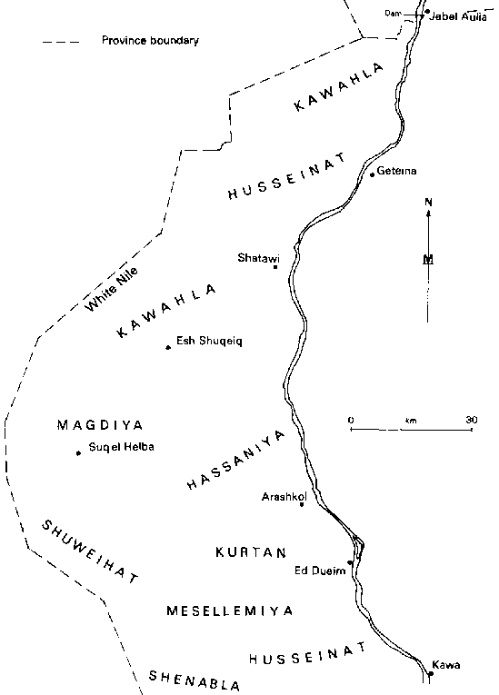
The region under discussion in this chapter stretches from Kawa (fig. 6.1) in the south (lat. 13° 45'N) to Jebel Aulia in the north (lat. 15 °15'N) and covers the west bank of the White Nile only.
Nomadism is both a way of life and an economic activity that exists in many parts of the dry and semi-dry lands of the Old World. The Sudan, with about two-thirds of its area classifiable as desert and savanna, has a large nomadic population of over 1.6 million persons, and these raise most of the country's livestock from which the local demand for meat and livestock products is met, while a surplus is usually available for export. Nomadism is old in the Sudan and its origins date back to the Meroitic period at least. At this time (before 200 A.D.) communities of Beja in the Red Sea area and the inhabitants of the Butana were already practicing nomadism (All, 1972). However, it was the coming of the Arabs, from the ninth century A.D., that enhanced nomadism and led to its spread to all parts of the semi-desert and savanna regions of northern Sudan. It should be noted, nevertheless, that nomadism remained largely an activity practiced by the Arabs and arabicized communities while the Negroid stocks, although they became more involved in animal-raising in varying degrees, remained basically settled people (Haaland, 1972). This shows how strong is the impact of socio-cultural values on economic activities. It has been observed that nomadism, like all other human cultural and economic systems, develops, declines, or changes its nature whenever appropriate forces of change operate on it at the right time and in the right direction.
Until the outbreak of the Second World War the majority of the population of the White Nile Region were nomads and semi-nomads (Mohammed, 1980). Since that time, however, nomadism has begun to decline and to change its nature to such an extent that at present probably not more than 15 per cent of the population of the region can be classified as nomads and semi-nomads. Yet animal-raising is practiced by the majority of the rural population. The purposes of this chapter are twofold: to discuss why and how nomadism has changed and to assess the future prospects for animal-raising in the region.
The first part of the chapter deals with the characteristics of nomadism in the White Nile up until 1937, whilst the second part deals with the nature of change that has taken place since then and the prospects for animal-rearing here in the future.
Nomadism before 1937
Nomadism in the White Nile region had from the start its own distinct identity, different from nomadism in other parts of the Sudan, and indeed from that in most parts of the world where nomadism was practiced. Whilst the nomads of the White Nile shared with other nomads the characteristics of raising animals (camels, cattle, goats, and sheep), having no permanent dwellings, and moving from one ecological region to another, they were able successfully to integrate animalraising with cultivation, which was practiced by them in all three ecological zones in which their movements occurred. This successful integration was due to the favourable physical and cultural characteristics of the region.
The Physical Setting
The White Nile region north of Kawa is part of the dry lands
of the Sahel region stretching through Northern Kordofan and
Darfur to Chad and beyond into West Africa. In the White Nile
there is a well-defined rainy season of three months, July to
September, with an average annual rainfall at Ed Dueim of about
375 mm. But rainfall fluctuates from one year to another and its
distribution in any one wet season is highly unpredictable. The
difference, however, between the project area and the lands of
Kordofan and Darfur to the west lies in the presence of the White
Nile, which not only contributes towards solving the problem of
the seasonally of water supply, but also has an effect on the
soils and cultivation systems of the region. The White Nile is a
perennial river flowing through a shallow trough with ill-defined
banks, especially on the western side, and is subject to an
annual rise and fall of about three metres. The rise takes place
between July and September/October, after which it starts to
fall. As a result extensive areas which are annually inundated
become available for cultivation and grazing. One should note
that the inundated areas to the north of El Alaqa and elsewhere
are rather more restricted in extent because of the comparative
steepness of the banks there. In addition to the riverain soils
that are annually inundated there are other types of soil in the
region:
- Heavy clay is to be found in depressions (maiyas or basins)
which are thought to represent former channels of the river, the
two most extensive of these being Es Sufi and Shabasha Basins
(fig. 1.4). These heavy clays were thought capable of cultivation
Year after year without being exhausted (Reid, 1930).
- The sands, or qoz soil, west of the basins, is made up of sandy
ridges and sand sheets separated in some parts by small clay
depressions. The qoz of the White Nile region is part of the
extensive qoz land of western Sudan. Sand is easy to cultivate
but loses its fertility when used for more than five to seven
Years without fallow.
The Human Setting
It is thought that the original inhabitants of the White Nile region were Nil0-Hamites from southern Sudan and Negroids from western Sudan. In about the twelfth century A.D. the Arabs began to arrive in the area and gradual occupation started (Amir, in press). Some mixing has taken place between the Arabs and the other stocks but most of the Nilotic tribes retreated southwards. The present population is predominantly Arab in origin, at least from the cultural point of view. However, it should not be thought that all the Arabs are homogeneous in their outlook towards nomadism. The majority of the Arabs of the White Nile are related to one or another of the three main Arab groups of the Sudan: the Gaalin, who are mostly settled people; the Guhayna, who are mostly nomadic; and the Kawahla, who, depending on the physical setting, may be either settled or nomadic. It happens that the majority of the Arabs of the White Nile belong to the Kawahla group and the Kawahla of this region are divided into three tribes, Kawahla (retaining the original name of the group), Hassaniya and Husseinat. Because of their dominance in terms of numbers and influence, the region was officially known, until recent years, as Dar Hassaniya. The Gaalin of the region are mainly the Showeihat, Kurtan, and Magdlya tribes, and none of these can be described as pure Gaalin. The Guhayna are represented by the Shenabla tribe, who are divided between the White Nile and Kordofan. There are also some smaller tribes that do not belong to any of the three Arab groups. These include the Jaafra, who dominate the town of Ed Dueim, the Mesellemiya, and the Arakiyin. All three of these tribes are more or less settled. It is to be observed that most of the Hassaniya and Husseinat occupy areas along the banks of the river and here they became attached to the riverain lands and developed titles to them. Most of the other tribes, including a substantial part of the Kawahla, occupy land away from the river, and have little claim to the riverain land. They were therefore from the start more nomadic and seminomadic than the Hassaniya and Husseinat (fig. 6.1).
Because of their dominance the Kawahla group of the White Nile deserve further attention. The Kawahla group of the Sudan, to whom the Kawahla of the White Nile belong, seem to have descended from Al Zubeir Ibn Al Awam, one of the famous disciples of the Prophet Muhammad. If this is true then the Kawahla must have been originally semisettlers, or at most semi-nomads. In their traditions the Kawahla state that they came from the Red Sea area, where they had settled for a brief period among the Beja. Then they moved westwards to different localities in the Sudan, with one group coming to the White Nile. It is not known whether the Kawahla group were truly nomadic or not when they arrived at the White Nile. What is certain, however, is that they, like the other Arab tribes of the Sudan, had a great affinity for animalrearing and learned irrigated and rain-fed cultivation only after arriving in the area; they adjusted their economic activity to make better use of the physical resources of the region without sacrificing their love for livestock. In this way they combined nomadism with cultivation in a manner unique among the Arabs of the Sudan and indeed unusual among the nomads of the world.
The Pattern of Land Use
The development of the region lay in cultivation and grazing, and for this it possesses both advantages and drawbacks. Three distinct arable land-use regions emerged: the White Nile flood plain, the basins, and the qoz.
The riverain cultivation was relatively easy to learn since neither irrigation nor extensive weed-clearing was required, and the soil was reasonably fertile since it was enriched every year. But the flood level of water in the river varied from one year to another, and this led to marked fluctuations in the area available for cultivation; the riverain crops were also often susceptible to insect attack. In the basins the annual rainfall of about 375 mm was generally sufficient for the aura crop, but falls fluctuate from one year to another and their distribution within the wet season is uneven. Under such marginal conditions the Arab tribes learned to use the teras (earth embankment) device so as to increase the concentration of rain at the expense of the area to be cultivated. This helped the situation, but was never a sufficient insurance against drought. In addition to the hazards presented by the rainfall there were also attacks by locusts, birds, and insects. Cultivation of the loose qoz sands was easy but there was always the danger of attacks by animals and the same hazards as those associated with cultivation of the basins.
The potential of the region for grazing also varied, since those areas within which cultivation was practiced were also highly suitable for livestock. The animals could also make use of aura stalks grown on the different areas. Animal raising, however, had the hazards of disease, failure of vegetation and water supply in drought years, and the possibility of raiding both by other tribes and by thieves. To spread the risk and to assure themselves of food supplies, the Arab tribes engaged in anima-raising as well as cultivation, using the resources of the different areas in an integrated and complementary way.
Their seasonal rhythm ran along the following lines. In the summer months, from April to June, the Arabs were found in their dammaring centres (pi. demur), which were usually established on comparatively high areas between the river flats and the basins. Water for domestic purposes or for animal use was obtained from the river or from wells dug nearby. The summer was a time of comparatively little activity centred upon repair and maintenance of the teras in time for the rain cultivation.
The tending of herds and flocks was performed by the younger members of the family whilst mature men visited the neighbouring markets (Petherick, 1861). in this way they contrasted with most other nomads in the Sudan, who at this period were involved in intense activity at the end of the dry season in finding grazing and water for their stock. However, once the rain started to fall further south (beginning of June), the young people took the livestock in a south-westerly direction to the qoz lands. Their journey was called shoggara and its purpose was to make use of the new green growth. In July, when the rain had set in at the dammaring centre, the adult men who were left there would start to plant feterita aura in the basins while the households would move westwards to the qoz in what was called the nushugh journey. Basin cultivation was left unattended or in charge of the aged. Most of the people used to stay for the whole of the kharif (rainy season) on the qoz attending to the animals; some people also cultivated aura and dukhn there. Water was found in local depressions, and grazing was plentiful although it lacked salt, a factor that compelled the nomads either to feed salts to the animals or to take the livestock back periodically to the basins to feed on the salt grazing there. By October the rain would have stopped and the water pools would begin to dry up. The nomads would then return eastwards towards the White Nile. They would first harvest the aura that had been sown in the basins. By November the river would start to fall, and once the soil was firm enough to allow a man to walk on it they used to start the cultivation of safra aura, a variety which was highly esteemed. Other crops, such as cotton, beans, onions, peppers and watermelon, were also sown (Reid, 1930). However, not all the riverain land was available for cultivation since some areas were covered by heavy grass and these were left for grazing. By April they would have harvested their crops on the riverain lands and a new cycle would have begun.
A number of points about the economic activities of the White Nile people should be noted. The first concerns the diversity in the activities, where three ecological zones were used for both cultivation and raising of animals. Secondly, the animals that were raised were mainly cattle, sheep, and goats, with very few camels. In fact, when Petherick visited the White Nile in 1845 he spoke of a few cattle, but considerable flocks of sheep and goats (Petherick, 1861). However, by 1930 the White Nile Arabs had developed their taste for camels and those who had many camels used to go to the gizu grazing area in the extreme north-western side of Darfur. Thirdly, with their different activities, and the comparative richness and limited extent of their dar, their movements were short, certainly compared with the Kababish, and usually not more than 30 to 40 miles. Petherick says that their usual journeys were seldom farther than one day's journey from the White Nile. Nevertheless, the nushugh encampments were constantly on the move, moving approximately every ten days (Reid, 1930). Fourthly, unlike most of the nomadic areas of the Sudan where land was communally owned, the land here- riverain and basin lands especially-was first owned by families and later by individuals (Reid, 1930). Most of the tribes who occupied areas away from the river did not develop individual titles to land, and so had no legal claim to any riverain land, though they were usually permitted to graze their animals on the river flats and near the basins.
From the foregoing it is clear that some of these peoples were in transition from nomad to sedentary. The fact that they were constantly on the move and that they had no permanent dwellings, or even permanent sites for their encampment near the river, is enough justification for accepting their classification as nomads. On the other hand, the short distance of movement, their close attachment to the land by virtue of having individual titles, suggests the contrary and puts nomadism in the White Nile into a special category. This is important because this "semi nomadic" situation made later transformations of their economy a comparatively easy matter.
Changes to the Traditional Nomadic Pattern
It is often claimed that the building of the Jebel Aulia Dam was the main factor leading to changes in nomadism in the White Nile. But the author thinks that, although the construction of the dam had very important effects on nomadism and that the year 1937 is therefore an important landmark, a whole host of other factors working together in a complex way are the ones really responsible for the reduction in nomadism. Some of these factors are inherent in the physical nature of the region and in the original cultural background of the people, and had begun to operate long before 1937. Other factors of change, such as the development of lorry transport and the growth of urban centres, particularly Greater Khartoum, are independent of the dam and their significant effects did not become clear until after the Second World War.
Factors for Change before the Dam
These operated in a conflicting way, some weakening nomadism while others strengthened it. The starting point for change in nomadism was when the nomads of the White Nile first developed individual ownership of the fertile land they cultivated year after year along the river and in the basins. Attachment to the land was reinforced by the fact that the White Nile is navigable throughout the year and that the region as a whole lay astride the caravan routes that linked Kordofan with the Fung Kingdom centred on Sennar and, later in the nineteenth century, with Khartoum. The region was therefore never isolated from other important centres. Furthermore, the example of the nearby Gezira Scheme during this century and the economic benefits that scheme has brought to its tenants made the population of the White Nile very aware of change. The end of the Mahdiya with the fall of Omdurman in 1898 was a doubleedged factor. Whilst those who returned to the White Nile from the wars were impoverished and consequently settled down, many of them eventually returned to nomadism after they had rebuilt their herds during a long period of peace and security. It even became possible for some of these people to go as far as the gizu, something that would have been impossible during the Fung Kingdom or Mahdiya times.
The Effect of the Dam
The objective of the Jebel Aulia Dam was to store White Nile water for Egyptian use by raising the river to flood levels from July. This level was held until the end of February and by April the reservoir was to be emptied. The raising of the water level meant that extensive areas of riverain land as far south as Jebelein, over 320 km south of Khartoum, are annually inundated from July until April instead of from July until November. Consequently this meant the loss of riverain land which was formerly available for cultivation as well as grazing between November and April. Furthermore, some of the pockets of higher land which were used as camp sites as well as for grazing were also lost. To compensate for the loss of cultivable riverain land the Sudan Government used some of the compensation money received from Egypt to establish irrigation schemes called the Alternative Livelihood Schemes. In addition, the high and constant level of the White Nile encouraged some private investors to establish private pump irrigation schemes. The agricultural development that followed the construction of the dam is discussed in chapter 5, but what concerns us here is the effects of the construction of the dam, and the consequent development of agriculture, upon nomadism. These effects can be seen in three areas: (I) risk-spreading strategy; (2) labour supply; and (3) reduced grazing land.
1. The two most important crops that have been grown under irrigation since the construction of the dam are the long staple cotton for cash and aura for subsistence. Other crops including groundnuts, wheat, and onions are also grown. Cotton, in spite of fluctuations in yield and in international prices, was on the whole a profitable and rewarding crop until recently (see chapter 5). Production of aura under irrigation gives a more assured yield than is the case in rainland systems. Under such circumstances the need for diversity in economic activities as a risk spreading strategy lost some of its importance along the White Nile (though the strategy was never lost sight of). The need, therefore, to raise many animals of different types became of less significance than it used to be.
2. Cotton is a labour demanding crop, especially during the picking season when all the family labour is needed and pickers need to be hired. There is also an overlap in the season of cultivation between cotton and aura and this makes the question of labour supply from July to February/March of crucial importance for the success of cultivation. Thus, it became no longer possible to find enough family labour to cultivate and to look after the animals at the same time.
3. Whilst the loss of the safra aura growing lands along the river was compensated for by the development of pump schemes, no compensation was provided for the loss of grazing areas along the river flats and the basin lands. Furthermore, the grazing left on the flats became infected with liver-fluke disease (abu-kabda) and animals often die as a result. A further difficulty is that the pump schemes severely restrict animal access to remaining White Nile riverain grazings.
The result of all this has been to compel most of the nomads and semi-nomads to settle in permanent villages and to devote more time and effort to cultivation than to animal-raising. However, certain variations in this respect can be identified and it is possible to divide the rural population of this region into three groups according to the degree of involvement of each group in cultivation and animal-raising.
First, the Arab el Bahr (Arabs of the riverain areas) have permanent villages, on higher lands near the White Nile, which are mixed in with the irrigation schemes. Good examples of such villages are Wad Nimr and Es Sufi. People here are fully settled and their main activity is irrigated cultivation. A few animals, mainly goats and cattle, are raised, the purpose of which is to supply milk to the family; one or more animals can be sold for ready cash if the need arises. Such animals are looked after by children and hired shepherds and the grazing areas rarely extend beyond the edge of the qoz, except in the rare case of those who possess a larger herd.
Second, the Arab el Dhahriya (Arabs of the back areas) have permanent villages on the eastern edge of the qoz where a line of villages is clearly visible on topographic maps (fig. 1.4). The people in these villages are involved in irrigated cultivation on the schemes that lie to the east as well as in the rainland tillage where aura and dukhn are produced. Animals, mainly cattle, but a few sheep and goats, are also raised. When animals are moved for comparatively long distances one or two adult members of the family may look after them; otherwise caring for animals is mainly the responsibility of women and children. Hired shepherds are also used. Animalraising is of secondary importance since cultivation is the main activity and the people here may be classified as semisettled more than anything else. A study of selected villages (Esh Sheikh el Hasin, Abqar, El Usheir, and Dahrein) revealed that although the people are pleased to be settled they would like, if possible, to raise more animals. This is because they say that cultivation in general is no longer profitable, the returns from cotton are small and aura and dukhn suffer badly from flocks of birds and various diseases. Nevertheless, raising more animals is difficult. Firstly there is not really sufficient labour during the July-February period to sustain the management of livestock and the cultivation of aura and cotton. The fact that more children go to school now exacerbates this difficulty. Secondly, exhaustion of the grazing potential due to overgrazing and over cultivation is a further limiting factor. Although there is a diversity of activities in this subregion, the apparent material conditions of the people are not really satisfactory and some of them help to solve this difficulty by earning money in Khartoum. Red-brickmaking at Gereif East was specifically mentioned.
Third, the Arab el Bahaiym (Arabs owning livestock) also live today largely in permanent villages, in this case on the qoz. However, it is within this group that some nomads with no fixed dwellings are still to be found. The people are engaged in both rainland cultivation (of aura and dukhn) and in the raising of animals, though here the latter seems to be more important. The animals, which include cattle, sheep, and goats, and some camels, are looked after by members of the family, but in certain cases hired strep herds are also used. The distances that the animals move are comparatively long. The villages, best represented by Esh Shuqeiq and Suq el Helba, are located near water points, such as wells, that are dug near dry watercourses or at the foot of hills. On the grounds of the permanency of their villages, the people of this area may be classified as semi nomads, although some nomads are still to be found.
The general directions and the time of the movements of all animals, whether of the riverain or of the qoz people, are the same, but the difference lies in the length of move meets. At the beginning of the rainy season when there is green growth animals are sent westwards and southwards to make use of the new grazing. By so doing they spare the pasture around the dammaring centres so that it can be used during the dry period, and at the same time avoid possible damage to cultivation by animals. The few live. stock of the riverain people rarely move beyond the edge of the qoz, but the animals belonging to both Arab el Dhahriya and Arab el Bahaiym move, according to the size of the herd, much further westwards to western and northern Kordofan, and southwards to the sandy and sparsely populated area south-east of Suq El Helba. This nushugh journey lasts until October or November. By that time the water pools dry up and the livestock have to return to the dammaring centres and cars where water is to be found. The animals subsist during this period, November to February, on natural grazing as well as on aura and dukhn stalks. Then in February and March the livestock are moved either towards the irrigation schemes where the crop residues are grazed, and later towards the river where some grazing is found, or towards the area of Esh Sheikh el Sidiq and further westwards where the leaves and pods of good stands of Acacia tortilis are utilized by the browsing animals, goats and camels. Later in the dry season, in May or even June, the animals return to the cars and wait in anticipation of an early rainy season.
Natural pastures alone cannot support the present level of livestock of the White Nile. Crop residues, mostly aura stalks, and edible oil cakes (ombaz) derived mainly from groundnut oil and cottonseed oil residues are widely used. The author was informed that the stalks of a hawasha (6 acres) are usually sold for between £S40 and £S100. The farmer removes the heads and leaves the stalks standing in the field. Then the buyer of the stalks allows his animals into the field. A sack of oil cakes, estimated as sufficient to supplement the feeding of ten head of cattle for ten days, costs £514. Resort to stalks or cake has been made necessary by the deteriorating conditions of pasture, by the limited extent of the afar compared, for example, with the afar of the Kababish, and by increases in population and settlement size. Financially buying fodder became possible once the Arabs were willing to sell milk to the numerous small cheese factories that have been established all over the region.
Other Factors of Change
The main changes in nomadism were triggered off by the construction of the Jebel Aulia Dam which facilitated the development of irrigated cultivation. Nevertheless, there are other factors that are continually operating against nomadism. These include the development of education, improved transport, rapid urban growth, and the development of the edible oil industries.
The White Nile region has been one of the favoured regions of the Sudan for the development of education. Bakht-er-Ruda Institute of Education was established near Ed Dueim in 1934 and served the whole of Sudan for the training of teachers. Consequently a number of schools were established in Ed Dueim and its environs to serve the institute as practice schools, and gradually, with the developing eagerness for education displayed in the area, more schools were built in the different villages of the region. The role of education has been twofold. Those children who join schools are no longer available, for eight months of the year, to look after the animals, and, furthermore, it has been observed that children who complete their primary education do not usually go back to nomadism.
The main town in the region is Ed Dueim, with a popula tion of 38,606 in 1983. But the region is well served by lorry and bus transport and thus it can be looked on as a part of the hinterland of Greater Khartoum itself, with over 1.5 million people. The region is also linked with the towns of the Gezira. Three main effects can be singled out. First, the region became the main supplier for the ever-growing demand for cheese for the urban dwellers. Secondly, it is from these towns where oil industries have developed that the White Nile region gets its oil cakes for the supplementary feeding of its animals. Thirdly, it became possible for many people, nomads and others, to travel to Greater Khartoum either for work or for leisure. The role of urban areas has not only been to provide opportunities for jobs, but they also act as centres for the diffusion of ideas. In this respect the role of Esh Shuqeiq, the largest animal market in the region, cannot be ignored.
Conclusion
All these factors have operated together to bring about a severe reduction in the importance of nomadism. In the past the population was described as nomadic or seminomadic. At present, the total nomadic population of Ed Dueim Area Council has been estimated in the 1983 census as 27,150 (or 12.2 per cent of a total population of 222,100 persons). This may be compared with a figure of over 20 per cent for the 1955/56 census for the same area. Although the whole problem is rendered more difficult than it appears from differences in definition between the censuses, the evidence does suggest that nomadism has declined continuously since the 1930s, when most of the population were described as nomads and semi-nomads.
The Future of Livestock-raising in the White Nile
Most of the livestock in the region, whether raised by settled or nomadic folk, subsist mainly on natural grazing and to some extent on crop residues. The introduction of ombaz (oil cake) is a recent phenomenon. When the dam was built and the Alternative Livelihood Schemes were established, the main consideration was to compensate for the safra land and little attention was in practice paid to the question of compensation for lost grazing land. It was thought by the District Commissioner at Ed Dueim in 1943 that "in addition to the grazing in the rain areas, there is also fodder grown in the Alternative Livelihood Schemes and the grazing provided by the falling reservoir during the drought season" (Mohammed, 1980). The fodder the District Commissioner referred to was Iubia (hyacinth bean, Dolichos lablab), a leguminous plant giving seeds for human consumption and fodder for animals. Lubia cultivation was part of the agricultural rotation on these schemes, but the people saw lubia as uneconomic in comparison with growing aura and cotton (Mohammed, 1980). In addition the authorities discouraged the appearance of animals on the schemes between August and March, being afraid that the livestock might harm the cotton plants and other crops. As a result lubia cultivation ceased and no other fodder was grown, and the animals had now to depend mainly on the qoz pasture, but the qoz land is also used for rain cultivation. With the increase in the numbers of the human and animal population overcultivation and overgrazing took place. The situation was aggravated by cutting of trees for wood for domestic energy, construction, and charcoalmaking. As a result severe degradation of the plant cover has taken place. A marked feature is the disappearance of trees, including Acacia seyal and Acacia tortilis, on which goats and camels like to browse, from all the White Nile area except the beds of some wadis and localized areas such as Esh Sheikh el Sidiq. Also famous species of grass and herbs, such as siha (Blepharis spp.) and hantud (Ipomea cardiosepala), have disappeared. However, where cultivation is not practiced the perennial gaw (Andropogon gayanus and Aristida funiculata) covers wide areas, which are thus protected from desertification. This is because gaw is a hardy perennial grass providing good grazing when green, but is largely unpalatable and avoided once it has become dry, with the result that it is rarely susceptible to overgrazing. Its chief enemy is the rainland cultivator. In areas where gaw or other similar plants are not dominant, moving sands may present a real threat to irrigated areas. Overcultivation, overgrazing, and clearance of wood all represent the degradation of the plant cover and so a loss of grazing potential.
It is often said that the Sudan is an agricultural country with the potential, given sound planning and efficient management, of solving its problems of national and regional food shortage, in particular its shortages of protein. This may also be said about the White Nile region. The economic development that has so far taken place has been mainly by horizontal expansion of irrigated cultivation, primarily for production of cotton. This policy has not solved the problem of poverty nor led to more efficient utilization of the available resources. Furthermore, the livestock wealth which is one of the most important resources of the region has lost some of its previous significance, at least from a social point of view if not from the point of absolute numbers. This should not be taken to mean that the changes that have occurred in nomadism were for the worse, because if the people were still nomads with large numbers of animals, the sheer numbers would have caused much more overgrazing than has occurred at present. The problem with the changes that have taken place is that in both animal-raising and cultivation there has been little change in the methods of production used, and consequently productivity has remained low and subject to great variations from one year to another. Furthermore, nearly all agricultural planners and administrators who have worked in the region believed there was a need to separate cotton cultivation from animal-raising; as a result the presence of animals on irrigation schemes was discouraged. During the early period of cotton-scheme development cotton prices were high and the people were attracted more to the cultivation of aura and cotton than to the cultivation of lubia, the fodder crop. That was unfortunate considering that the White Nile region had developed a tradition of mixed cultivation and animal-rearing.
The author thinks that of all the regions of the Sudan that would be suitable for mixed agriculture, the White Nile can be made one of the best. The potential of the region for such development includes: the availability of water and agricultural land; the deep-rooted traditions of the people reinforced by the development of a cheese industry; the availability of a continuous supply of young animals from the qoz areas to the west; and the nearness to Greater Khartoum and the towns of the Gezira, all of which need uninterrupted supplies of meat, milk, and milk products. The advantages that can be gained from such a development are many. At present soil salinity is one of the main problems of irrigated cultivation in the region and this can be greatly reduced by the cultivation of the right fodder crop. Nitrogen-fixing fodder crops can also be grown to further improve the soil. Farming is also likely to be more profitable in a system where cotton is the backbone. It is true that no serious study has yet been done to prove this, but judging from the high price of oil cakes, and the low-level returns from cotton, a case for the profitability of mixed farming would seem to exist. A first step might be to experiment with fallow land under an appropriate fodder crop. If the experiment proves successful a thoroughgoing replanning and reassessment of the area should be undertaken. However, it should be remembered that sound planning for mixed farming, as for most other forms of development, must include a complete assessment of the necessary infrastructure, of which transport, markets, and storage facilities are among the most important factors.
References
Ali, A. M. 1972."Maroitic Settlement of the Butana."In P. J. Ucko et al., Mon. Settlement and Urbanism, pp. 639-646.
Cunnison, LG., and W. James, eds. 1972. Essays in Sudan Ethnography. Hurst, London.
El Amir, T. in press. The Sudanese Arab Racial Group in the White Nile. university of Khartoum Press, Khartoum. (In Arabic.)
Haaland, R. 1972. ,Nomadism as a career among the Sedentaries of the Sudan Savanna Belt. " In I. G. Cunniton and W. James, Essays in Sudan Ethnography.
Mohammed, A. A.1980. White Nile Arabs. Athlone Press, London.
Petherick,J. 1861.Egypt, the Sudan and Central Africa. Tinsley Press, London.
Reid, J. A. 1930."Some Notes on the Tribes of White Nile Province`' Sudan Notes and Records, 13: 149-169.
Ucko, P. J. R. Tringham, and G. W. Dimbleby, eds. 1972. Man, Settlement and Urbanism. Duckworth, London.