General methodology
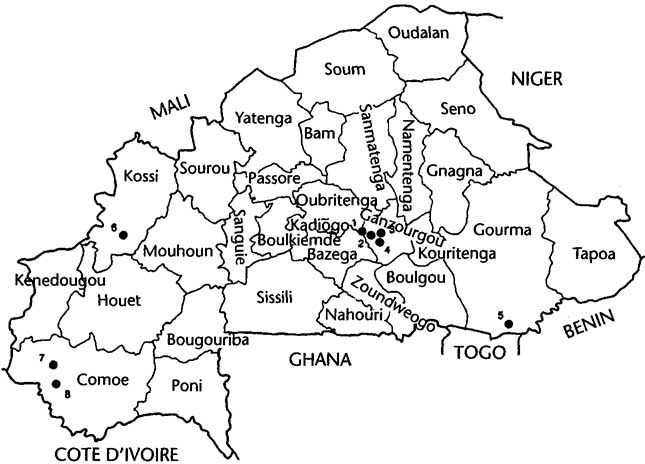
The Burkina case study research followed the basic Land Settlement Review (LSR) model.1 The case study was based on a blend of quantitative and qualitative research at four study sites - the AVV (Autorité pour l'Aménagement des Vallées des Volta, or Volta Valley Authority) planned settlements in the upper Nakambe (ex-White Volta) [1] river basin, spontaneous settlement in the southwest "cotton boom" area of Solenzo [2] in the Mouhoun (ex-Black Volta) river basin, spontaneous settlement [3] in the area surrounding the newly created hydroelectric dam in the Kompienga river basin [4], and spontaneous settlement into the Niangoloko subsector and the neighbouring Classified Forest at Toumousseni near the Leraba and Comoe river basins (Figure 2). The interviews with study farmers revolved around four surveys:
1. frequent visitation surveys of crop, livestock, and non-farm production activities for 25 to 35 households at three of the four sites (excluding Niangoloko);
2. a structured interview with 25 to 35 households at each site regarding their immigration history and historic relationships with the indigenous hosts and immigrant agriculturalists and pastoralists;
3. a structured interview with 25 to 35 women at each of the study sites relating to their activities before and after coming to the site; and
4. a series of sample questions to be used as guidelines in the development of a brief history of natural resource management issues.
The Rapid Assessment Procedure
In the original LSR methodology, it was assumed that analysis of immigration trends could be based on existing data. An inventory of existing physical and socioeconomic data for the OCP river basins was summarized in a four-volume Preparatory Phase Study conducted by Hunting Technical Services Limited [6]. The 1985 national census for Burkina provided information on interregional population trends [6-28]. More specific information on the OCP river basins was obtained from an aerial photo survey. This particular survey, commissioned by the OCP as part of a ten-year assessment of the socioeconomic impact of control, compared aerial photos of a sub-sample of the major river basins in 1983 with baseline photographs from 1974 [5]. This OCP study provided the first concrete information on the relative rates and patterns of settlement in the different river basins.
While the OCP aerial photo survey and the 1985 national census were very useful, they did not provide the type of up-to-date information needed on intraregional and interregional immigration. The majority of the printed analyses were aggregated at the administrative province level or in the smaller, more numerous, administrative departments. As such, they did not examine more specific immigration within regions to areas adjacent to the river basins. When these intraregional immigration trends were examined, by comparing the 1975 and 1985 census figures for specific villages, we encountered other problems. For example, some villages with sizeable populations in 1985 did not even exist as official villages in 1975. In another case, a newly created administrative department had not inherited all of the old census records.
Figure 2.Case study research sites in Burkina Faso
Source: McMillan, D., J.B. Nana and K. Savadogo, 1990 [9].
More accurate information was available for the AVV planned settlements at Rapadama and Linoghin. Here, sociologists working with the AVV extension staff developed a simple one-line interview format that sought basic information about year of immigration, area of origin, and the means by which the spontaneous settlers moving into the surrounding area had acquired new land [29]. Some of the same sociologists and research assistants used a similar form to study spontaneous immigration into the Kompienga river basin 0. B. Nana, personal communication) [30].
The LSR Rapid Assessment Procedure
A similar, simple interview format was adopted to study immigration trends at the study sites where accurate immigration data were not available. The sites studied included the Solenzo subsector, the Niangoloko subsector, four villages around the Classified Forest at Toumousseni, and Kompienga, a town that developed at the construction site of the Kompienga Dam.
At Niangoloko, Toumousseni, and Solenzo, village leaders were asked to identify all of the households within a particular geographical unit of the village who were identified as "immigrant." Since all but a small nucleus of the settlement at Kompienga had immigrated since 1985 and had never been counted, we attempted to conduct a fairly accurate census of the entire population. Leaders were asked the approximate year when members of a family unit first immigrated, where they came from, approximate family size, and the household head's primary and secondary occupation. These village leaders were often interviewed in a group setting, which allowed them to cross-validate information.
An average of one month of research assistant's time was required to conduct the rapid assessment procedure at each of the major study sites. One week was required for the four villages adjacent to the Classified Forest at Toumousseni because of the low rates of immigration to the area.
Results
SOLENZO Immigration to the areas adjacent to the Mouhoun (ex-Black Volta) river basin in southwestern Burkina Faso was already well under way when the Onchocerciasis Control Programme began in 1974 [31] (Figure 3). This may be attributed to the extremely successful cotton extension programme that has been promoted in Burkina's upper southwest since the 1950s.
This strong current of immigration toward the prosperous cotton boom areas has continued. Census figures showed that the Solenzo population more than doubled between 1975 and 1985; 38% of this population increase was attributed to immigration. The aerial photo survey showed a striking six-fold increase in new lands cleared for the entire Monhoun (ex-Black Volta) river basin between 1974 and 1984 [5]. This continuous stream of immigration, coupled with the extensive cultivation practices used by most migrants, is putting stress on area soils. Planners are especially concerned about a potential decline in soil fertility caused by decreases in soil organic matter [32]. More intensive cultivation practices, using manure and the reincorporation of crop residues, have enjoyed only limited success; mineral fertilizer is expensive and is used primarily on the cotton and maize grown for sale [9, 32-34].
Current efforts to promote the development of more intensive, environmentally sustainable crop and livestock production practices focus on the development of village land management associations. A core premise of the village land management concept or PNGTV (Programme Nationale pour le Gestion des Terroirs Villageois) is that spontaneous immigrants tend to use extensive cultivation practices because they have insecure land tenure rights. The PNGTV programme hopes to counter this trend by delineating village boundaries and establishing village land management committees to control access to and use of village lands. Other policy innovations include restricting the total area that farmers are allowed to cultivate, promoting new intensive extension themes, and stricter regulation of the terms under which new migrants may occupy village lands.
The PNGTV model is considered relevant to the entire Solenzo region. The results of the farming census survey and rapid assessment survey suggest, however, that receptivity to the programme will be very different in the older villages away from the Mouhoun River and in those along the river basin's edge.
Our best evidence for this is in the recorded differences in the total area farmed and net crop income per active worker for the mini-tractor farmers at the two villages in the farming systems survey [33,34]. The mini-tractor farmers at Dar-es-Salaam/Kie, the village closest to the river basin, farmed an area per active worker that was one-and-a-half times the average area per active worker for mini-tractor farmers in the more inland village of Daboura [9, 34]
Daboura, located along the main highway linking the provincial capital Dedougou with Solenzo, was one of the first villages to experience extensive immigration - much of it before 1974. Dar-es-Salaam possesses a vast uninhabited bush between the core village and the Mouhoun (ex-Black Volta) River; Daboura does not. Because of this large supply of "new" land, the Dares-Salaam settlers and hosts can still expand toward the river. In contrast, the Daboura farmers have little choice but to raise crop productivity through increased use of fertilizer and labour or move to villages like Dar-es-Salaam/Kie where "new" land is still available.
The rapid assessment approach showed that over 46% of the recorded immigrant households (51% if one excludes immigration to the commercial centre of Solenzo) were concentrated in five villages in the vicinity of Dar-es-Salaam. The vast majority of this immigration has occurred since 1974. The incentive to invest in more sustainable crop, livestock and forestry management practices is likely to be less in these five villages adjacent to the river basins. Here "new" land that can be easily cleared is generally still available. These areas are also usually less accessible, with little, if any, basic infrastructure or support services. Efforts to promote sound environmental management are likely to be more successful in these villages when they are linked with a strong concerted effort to work with settlers and hosts to develop roads and services that will be beneficial to both groups. These improved services raise rural living standards and create an incentive to invest before land shortages leave no other option.
These findings had a significant impact on the willingness of national government, regional political and development authorities to support a pilot project to expand the AVV's development programmes to include spontaneous as well as sponsored settlers. This experimental programme was first tried at Linoghin and Rapadama, for the obvious reason that these were the two settlement groups that had experienced the highest rates of new land settlement [29]. A similar programme to incorporate the spontaneous settlers at Mogtedo and Mogtedo-Bombore was initiated in 1989 (Figure 4).
KOMPIENGA There was very little spontaneous immigration to the isolated Kompienga river basin in the southernmost part of the Gourma province until 1982. Living in small, scattered, low-density settlements, the indigenous Gourmantche and Yarse had generally shunned cultivation near the fly-ridden, low-lying rivers [30]. Nevertheless, it was obvious that this situation would change once the government constructed the country's first hydroelectric dam on the Togo-Burkina border (Figure 5). Based on the 1985 census, demographers predicted that construction of the Kompienga dam would briny about a 15% increase in immigration to the Fada planning area between 1985 and 1990,15% between 1990 and 1995, and 8% between 1995 and 2000 [28].
While this 15% figure between 1985 and 1990 might be valid for the province as a whole, it is an inadequate depiction of the sudden influx that occurred in the valley itself. The entire Kompienga river basin experienced a sudden, dramatic increase in agricultural immigration after 1985. This immigration was especially important in the area immediately adjacent to the dam construction site, which became Kompienga town.
By August 1989, when the rapid assessment census was conducted, the town of Kompienga, previously consisting of only three large compounds in the early 1980s, numbered 3,239 persons, excluding civil servants. Only 63 (15%) of the heads of household indicated that they had worked on the dam project, and 310 (75%) of the household heads reported that either agriculture or livestock production was their primary activity. In short, although government officials still thought of the community as essentially one of unemployed former dam employees, the census and case study interviews showed that subsequent immigration had created a new community attracted to the area by the prospect of acquiring irrigated farmland near the dam.
By 1989, virtually the entire area within a ten kilometre radius of the town of Kompienga had been occupied. The farming systems survey confirmed interviews with farmers and extension staff that described the settlers' extensive farming systems. Even if farmers wanted to farm more intensively, this was difficult. Neither extension services, nor plows, nor fertilizer were available to the town farmers. In contrast to the town of Kompienga, the villages that were to be either totally or partially flooded by the dam-created lake had access to fertilizer, plows and extension services through a well organized relocation programme.
These high rates of immigration displaced the indigenous and immigrant pastoralists from land that was formerly used for grazing. The expulsion of the Fulbe from northern Ghana in late 1988 further increased competition for scarce pasture. During the 1988 and 1989 rainy seasons there were repeated complaints of Fulbe cattle destroying farmers' fields and even reports of physical violence.
Future development planning for the Kompienga river basin area will no doubt require some type of area zoning for crop production, grazing and forestry. Spontaneous immigration has occurred on such a scale, however, that any future zoning will involve relocating many homesteads and fields. The hostility generated by this relocation will exacerbate the already stressed relations between the agriculturalists and pastoralists and may create new stresses between hosts and immigrants.
The type of area planning to be funded for the Kompienga basin is still undecided. The information on Kompienga, however, has fairly immediate significance for policy planning near Burkina's second major hydroelectric dam, now under construction at Bagre. In particular, it suggests that:
1. Participatory natural resource zoning to protect the land tenure rights of the indigenous pastoralists and hosts needs to be carried out at a very early stage, well before the actual construction of the dam; and
2. Crop and livestock extension services must be expanded well in advance of the completion of the dam in order to work with the large numbers of spontaneous immigrants who can be expected to move into the area almost immediately.
NIANGOLOKO AND THE CLASSIFIED FOREST AT TOUMOUSSENI Immigration to the Comoe and Leraba River Basins shares many similarities with early immigration to Kompienga. Before 1974, the river basins were highly infected with onchocerciasis. Here too, the indigenous people have traditionally shunned cultivation of the fly-ridden, low-lying areas near the rivers. These same sparse population densities made the area a popular transit grazing spot with the Fulbe agropastoralists. It also made it possible to designate vast areas of the Comoe Province as classified forests during the 1950s [36].
Despite some of the highest rainfall in the country, the Comoe and Leraba river basins have experienced only a threefold increase in the total percentage of land under cultivation between 1974 and 1984, according to the 1984 OCP aerial photo survey 15, p. 19]. This compares with a six-fold increase for the Mouhoun and its major tributaries (ex-Black Volta) near Solenzo. The low immigration to the river basins reflects the lower net immigration figures for the Comoe province between 1975 and 1985 - a net increase of 16,513 persons versus 137,957; 56,439; and 56,439 for the Houet, Kossi and Mouhoun provinces adjacent to the more northern Mouhoun Basin and its effluents and 79,110 for the Sissili province adjacent to the Sissili province [Ref. 28].
The results of the rapid assessment census suggest that immigration to the Niangoloko subsector within the Comoe Province has increased dramatically since 1985. This initial increase in immigration can be attributed to the pastoralists who began moving into the area as active settlement in the more northern river basins displaced them from their traditional grazing areas. Since 1988 a series of violent conflicts between agriculturalists and pastoralists in northern Côte d'Ivoire forced a large number of Fulbe and their herds back across the Côte d'Ivoire-Burkina border. Agricultural immigration to the Niangoloko region has increased since 1983, mostly because of Burkinabè immigrants returning from Côte d'Ivoire in the wake of a downturn in the coastal country's plantation economy. These immigrants are primarily responsible for the recent (since 1985) increase in draft animal and cotton cultivation that we see in certain areas of the Leraba [35].
The rapid assessment census confirmed that, in Niangoloko as in other areas, the largest number of immigrants were attracted to major market and administrative centres and neighbouring villages [35]. Nevertheless, a rapid assessment of "immigrant" households in four more isolated villages along the edge of the Classified Forest at Toumousseni showed a substantial increase in immigration as well (Figure 6). This immigration repeats the early pattern observed for the Niangoloko subsector in that a majority of the immigrant households tend to be pastoralists pushed into the forests by increased agricultural settlement in the more accessible river basins [35].
Although total immigration to the Niangoloko subsector is still less than what was recorded at Solenzo, we expect it to increase. The main impetus for the predicted increase will be the large numbers of Burkinabè expected to return from Côte d'Ivoire. We can also anticipate that a significant proportion of the immigration will be redirected to the southwest as the more northern river basins in the Kossi, Mouhoun, Bougouriba and Houet provinces that were resettled earlier become saturated.
This finding has significant policy implications for natural resource management in Burkina. The Comoe Province includes the largest area of classified national forests of any province in the country [35]. In the past these areas were protected by the river basins' low population densities. As immigration increases, it will be increasingly difficult to restrict illegal grazing and farming in the protected forests.
Forest management projects that enlist the active participation of the local populations are more likely to be successful. A model for this is a series of highly successful projects that have helped agriculturalist and pastoralist extension groups harvest and sell renewable forest products like honey, karite butter, wood and charcoal. The genius of these sorts of multiple-use forest projects is that they create a population with a vested economic interest in protecting and managing the forests.
In view of growing evidence that the rate of immigration is increasing, it would be prudent to expand the development of these multiple use forest management programmes into Comoe Province [35]. Our rapid assessment survey of the Niangoloko subsector showed an annual immigration of 85 families in 1987, 90 in 1988, and 61 in 1989, even without a full census of the Fulbe pastoralists, which would undoubtedly more than double the figures. These numbers are fast approaching the numbers recorded for the Solenzo subsector (81 families in 1986, 67 in 1987, and 120 in 1988). The Solenzo region is well known as an area of active spontaneous immigration. Clearly, Niangoloko is also emerging as such an area.
In summary, the rapid assessment procedure
using both qualitative and quantitative approaches that we used in Burkina Faso
offers one cost-effective, rapid method for describing intraregional and interregional
immigration trends with greater precision.
Especially important was the ability of these simple studies to depict:
1. important differences among the villages within a region in terms of the rate of new lands settlement;
2. more recent trends in the five years since the last census; and
3. background information on the settlers' occupations and areas of origin.
This information provides a sounder basis for the allocation of funding to facilitate sustainable development in areas undergoing spontaneous settlement.
It is important, however, to stress some of the limitations as well as the strengths of this approach. Although the rapid assessment procedures provide an overview of settlement trends for immigrants still living in the villages, it tells us nothing about the settlers who immigrated into an area, mined the soil and left.
Longitudinal research, over a ten year period, with a single group of settlers living in the AVV planned settlements at Mogtedo [9, 25, 37-42], showed that many of the original study households eventually left the area. These included some of the most successful commercial farmers in the project. Of the 255 households who acquired project farms in the AVV settlements at Mogtedo between 1974 and 1980, only 58% (148) were still living there in 1989 [38,39]. Eighty-one percent of the 345 households that claimed AVV farms at Mogtedo-Bombore in 1980 and 1981 were still residing there in 1989.
A second problem with the technique has to do with the limitations of a single interview survey to give accurate information on income trends. In most cases we found that the information we gathered on the estimated total production for each crop gave an accurate portrayal of the households' crop production patterns and the subdivision of private and cooperative crop production activities within families. The data on livestock and non-farm production, however, were extremely unreliable. The most accurate and frank information that we obtained on these and other complex topics like host-settler and pastoralist-agriculturalist conflicts, was in the villages where team members had worked or lived for many years.
To conclude, no one doubts that the successful control of river blindness can have a substantial economic impact on development in the landlocked Sahelian countries. This development potential is a finite resource, however, and therefore needs to be managed. For this reason there is an urgent need to assist national governments, foreign donors and local populations with the design of more appropriate planning policies. Especially important is the need to work with spontaneous settlement as it is occurring - not after problems have emerged.
Not all of the research techniques
that the Land Settlement Review developed were equally successful. Nevertheless, these
techniques could be used as a point of departure for the development of a handbook of
practical guidelines, topics for data collection and data gathering aids to improve policy
planning in the OCP river basins. Current efforts by anthropologists to incorporate
anthropological approaches to improve programme effectiveness in nutrition and primary
health care [40,41] and in farming systems research and extension [42-44] provide a model
for how this standardization might be carried out.
The authors would like to express their gratitude
to Carol Lauriault, Priscilla Reining, Thayes Scudder and Mary Sies who provided useful
comments on various drafts of this paper.
1. McMillan D, Painter T. Scudder T. Final Report of
the Land Settlement Review: Settlement Experiences and Development Strategies in the
Onchocerciasis Controlled Areas of West Africa. Binghamton, NY: IDA (Institute for
Development Anthropology), 1990.
2. OCP (Onchocerciasis Control Programme), Joint Programme Committee. Onchocerciasis Control Programme in West Africa Progress Report of the World Health Organization for 1990 (1 September 1989-31 August 1990). Report No. JPC11.2 (OCP/PR/90). Ouagadougou: Onchocerciasis Control Programme, 1990.
3. Remme J. Zongo JB. Demographic aspects of the epidemiology and control of onchocerciasis in West Africa. In: Service MW, ed. Demography and Vector Borne Diseases. Boca Raton Florida: CRC Press, Inc., 1989.
4. OCP. Report on the Evaluation of the Socioeconomic Impact of the Onchocerciasis Control Programme. Report No. JPC7.3 (OCP/86.7). Ouagadougou: OCP, 1986.
5. Hervouet JP, Clanet JC, Paris F. Some H. Settlement of the valleys protected from Onchocerciasis after ten years of vector control in Burkina. (OCP/GVA/84.5). Ouagadougou: OCP, 1984.
6. Hunting Technical Services, Ltd. Socioeconomic Development Studies of the Onchocerciasis Control Programme Area (4 Volumes). London: Hunting Technical Servies, Ltd., 1988.
7. Akwabi-Ameyaw K. Land Settlement Review, Country Case Study: Ghana. Binghamton, NY: IDA, 1990.
8. Koenig D. Land Settlement Review, Country Case Study: Mali. Binghamton, NY: IDA, 1990.
9. McMillan D, Nana JB, Savadogo K. Land Settlement Review, Country Case Study: Burkina Faso. Binghamton, NY: IDA, 1990: 104-106.
10. Painter T. Land Settlement Review, Country Case Study: Togo. Binghamton, NY: IDA, 1990.
11. Ancey G. Facteurs et systémes de production dans la société mossi d'aujourd'hui: migrations, travail, terre et capital. In: Enquéte sur les mouvements de population a partir du pays Mossi, Tome 11. Ouagadougou, Paris: ORSTOM (Office de la Recherche Scientifique et Technique Outre-Mer), 1974.
12. Benoit M. Espaces agraires mossi en pays bwa. 2 tomes. Ouagadougou, Paris: ORSTOM, 1973.
13. Benoit M. Le champ spatial mossi dans les pays du Voun-Houet de la Volta Noire (Cercle de Nouna, Haute-Volta). Cahiers des Sciences Humaines 1973; X(2): 115-137.
14. Capron J, Kohler JM. Environnement sociologique des migrations agricoles. In: Enquête sur les mouvements de population a partir du pays mossi, Tome 1. Ouagadougou, Paris: ORSTOM, 1974.
15. Kohler JM. Activités agricoles et transformation socio-économique de l'ouest du mossi. Paris: ORSTOM, 1972.
16. Marchal JY. Géographie des aires d'émigration en pays mossi. In: Enquéte sur les mouvements de population à partir du pays Mossi, Dossier 11, Fascicule 3. Ouagadougou, Paris: ORSTOM, 1975.
17. Remy G. Les migrations de travail et les mouvements de colonisation mossi. Paris: ORSTOM, 1973.
18. Angel S. Spontaneous land settlement on rural frontiers: an agenda for a global approach. Paper presented at the International Seminar on Planning for Settlements in Rural Regions: The Case of Spontaneous Settlements. Nairobi, Kenya, 11-20 November 1985.
19. Becker BK. Spontaneous/induced rural settlements in Brazilian Amazonia. Paper presented at the International Seminar on Planning for Settlements in Rural Regions: The Case of Spontaneous Settlements. Nairobi, Kenya 11-20 November 1985.
20. Bharin TS. Review and evaluation of attempts to direct migrants to frontier areas through land colonization schemes. In: Population Distribution Policies in Development Planning. Population Studies No. 75. NY, NY: United Nations, Department of International Economic and Social Affairs, 1981.
21. Couty P. Marchal JY, Pélissier P. Poussi M, Savonnet G. Schwartz A, eds. Maîtrise de l'espace agraire et développement en afrique tropicale: logique paysanne et rationalité technique. Paris: ORSTOM, 1979.
22. Dollfus O. Phénoménes pionniers et problémes de frontiéres: quelques remarques en guise de conclusion. In: Les Phénoménes de "Frontiére" dans les pas tropicaux. Travaux et Mémoires de l'Institut des Hautes Etudes de l'Amérique Latine 32: 445-448.
23. McMillan D. Land Settlement Review, Draft Country Case Study: Burkina Faso (Analysis of Material from Site Reports and Other Research at AW-UP1, Kompienga, Solenzo, and Niangoloko). Binghamton, NY: IDA, 1990.
24. Weitz R. Pelley D, Applebaum L. Employment and income generation in new settlement projets Geneva: International Labour Office 10/WP3. World Employment Paper 10, Working Papers 3, 1978.
25. Van Raay GT, Hilhorst JGM. Land settlement and regional development in the tropics: results, prospects and options. The Hague: Institute for Social Studies Advisory Board, February 1981.
26. Scudder T. The development potential of new lands settlement in the tropics and subtropics: a global state-of-the-art evaluation with specific emphasis on policy implications. Binghamton, NY: IDA, 1981.
27. Scudder T. The experience of the World Bank with government-sponsored land settlement. Report No. 5625, Operations Evaluation Department. Washington, DC: The World Bank, 1985.
28. SEPIA (Société d'Etudes de Projets d'Investissement en Afrique). Etude Démographique: Projections de la population Burkinabé pour les années 1990, 1995 et 2000. Ouagadougou: SEPIA for the Comité National de Lutte Contre la Desertification, Plan d'Action National pour l'Environnement (PANE), 1990.
29. AVV (Aménagement des Vallées des Volta). Programme réforme agraire et gestion de l'espace UP1-Zorgho (UD de Linoghin, UD de Rapadama). Rapport general. Ouagadougou: DEPC, Service Etudes et Programmes, 1988.
30. Agrotechnik. Etude de développement régional ans le bassin versant de la Kompienga. Rapport final. Référence No. 84.70.049, 1989.
31. Nana JB. Rapport sur le site de sous-secteur de Solenzo. Land Settlement Review Draft Site Report. Binghamton, NY: IDA, 1989.
32. CRPA (Centre Regional de Promotion Agro-pastorale de la Boucle du Monhoun). Rapport d'achévement de projet. Projet de développement agricole de la boucle du monhoun (ex-volta noire). Dedougou: CRPA du Mouhoun, 1989.
33. Savadogo K, Sanders J. Farm and female productivities in the river blindness settlement programs of Burkina Faso. Land Settlement Review Draft Site Report. Binghamton, NY: IDA 1989.
34. Savadogo K. Factors explaining household food production systems. Land Settlement Review Draft Site Report. Binghamton, NY: IDA, 1989.
35. Nana JB. Rapport sur le site de la zone de sous-secteur de Niangoloko et de la forét classée de toumousseini. Land Settlement Review Draft Site Report. Binghamton, NY: IDA, 1989.
36. Murphy J. Sprey L. The Volta Valley Authority: socioeconomic evaluation of a resettlement project in Upper Volta. West Lafayette, Indiana: Purdue University, Department of Agricultural Economics, 1980.
37. McMillan D. A resettlement project in Upper Volta. Ph.D. Dissertation, Anthropology Department. Evanston, Illinois: Northwestern University, 1983.
38. AVV. L'Impact socio-économique du programme de lutte contre l'onchocercose au Burkina (1974-1984) Ouagadougou: AVV. Juin, 1985.
39. Sawadogo S. Rapport préliminaire départs de Mogtedo et Mogtedo-Bombore. Land Settlement Review Draft Site Report. Binghamton: IDA, 1989
40. Scrimshaw SCM, Hurtado E. Rapid assessment procedures for nutrition and primary health care: anthropological approaches to improving programme effectiveness. Los Angeles: UCLA Latin American Center, 1987.
41. Scrimshaw SCM, Hurtado E. Anthropological involvement in the Central American Diarrheal Disease Control Project. Soc Sci Med 1988; 27, 1: 7-105.
42. Fresco LO, Poats SV. Farming systems research and extension: an approach to solving food problems in Africa. In: Hansen A and McMillan DE, eds. Food in Sub-Saharan Africa. Boulder: Lynne Rienner Publishers, Inc., 1886.
43. Hansen A. Learning from experience: implementing farming systems research and extension in the Malawi Agricultural Research Project. In: McMillan D., ed. Anthropology and Food Policy. Athens: University of Georgia Press, 1991.
44. Shaner WW, Philipp PF, Schmehl
WR. Farming systems research and development: guidelines for developing countries.
Boulder, Colorado: Westview Press, 1982.
Introduction
The Latinas and AIDS research project
AIDS prevention workshops for Latinas
Implications for future research and application
Conclusion
References
Additional reading
Annex A: Summary of workshop illustrated fact and fiction card data
Annex B: Individual card responses for Latina subset, workshop data
By Laura Ramos
Laura Ramos is at the School of Public Health, UCLA.
This paper provides a detailed description of the use of RAP to identify difficult to reach populations who may be at higher than normal risk for contracting AIDS. Additionally, the step by step development of a visually based testing instrument for assessing knowledge gain in small groups workshops on sexual behavior and AIDS risks to Latina women in Los Angeles County is described. The procedures outlined may be of significant value to those developing illustrative educational materials on AIDS prevention for low and/or non-literate populations. - Eds.
THE AIDS EPIDEMIC in the United States has now increased to more than 179,000 cases [CDC, June 1991]. While the majority of these cases have been adult and adolescent males, the number of women affected by AIDS is increasing at a rapid pace. There are now almost 18,000 women's AIDS cases, and that official number is considered to be a underestimate of the true level of this problem in women [ Chu, et al., July 1990]. Within the women's AIDS cases, Latinas (20%) are disproportionately represented compared to their estimated proportion of the national population (8% respectively) [Worth, 1990a, 1990b]. Of the small number of documented lesbian AIDS cases, Latinas represent 42% [Chu, November 1990]. Thus it is important to study the effect of the AIDS epidemic within Latina populations in the United States, and to develop culturally specific methods of AIDS prevention which will be effective in stemming the tide of the epidemic in Latina populations [Arguelles and Rivero, 1990]. This concept is well stated in Scrimshaw, et al.'s, article, "The AIDS Rapid Anthropological Assessment Procedures: A Tool for Health Education Planning and Evaluation" [Scrimshaw, Spring 1991]:
"The AIDS epidemic has
highlighted the need for both quantitative and qualitative research into social and
cultural factors influencing human behaviour, particularly in terms of preventive measures
and supportive care. Baseline research prior to programme design is needed to provide
information to guide the development of health education interventions. Formative research
in which educational materials are tested is equally needed to refine those interventions
in a way that makes them culturally appropriate, well understood and accepted. Obtaining
these data is often complicated by the fact that behaviours related to the prevention and
treatment of AIDS are usually considered personal and confidential. They may not be
readily revealed publicly and are constantly changing. The issues which can be discussed
and the manner in which they are discussed vary from culture to culture. Efficient methods
of collecting this information are essential to health education efforts both in terms of
accuracy and speed."