The Setting :
Socioeconomic
Setting
Ethiopia is a developing African country located
between 3°N and 15°N, and
33°E and 48°E.
Ethiopia is estimated to be about 1.2 million square
kilometers, two thirds of which is mountainous, lying between 1700-3000 meters
above sea level. The western and eastern highlands rise to 4000 meters with the
Rift Valley dissecting them. More than 60 percent of Ethiopians live in these
highlands. Drought, deforestation and soil erosion are the leading
environmental problems in the region. At the turn of the 20th
century, 40 percent of Ethiopia’s land surface was covered with dense
forests. This has been reduced to only 4 percent. Land degradation in Ethiopia is aggravated because of high population
density and the traditional techniques of cultivation.
Ethiopia is called the water tower of Africa. It is home to many rivers such as the Blue Nile and Wabe Shebelle, making it potentially suitable for irrigated
agriculture. The FAO estimates that Ethiopia has the potential to irrigate 3.5
million hectares of land (FAO/GIEWS, 12/19/1997).
At the end of
the El Niño in the middle of 1998, a war started
between Ethiopia and Eritrea. The war began on May 12, at a
time when Ethiopians were coping with the adverse impacts of El Niño. The conflict was an added constraint on the El Niño-related responses by the government and the people.
About 450,000 Ethiopians who live in the border areas occupied by Eritrea were displaced and became dependent on
food aid. They lost their animals, seeds, and harvests. Other farmers in the
border areas could not plant, because of the lack of security and occasional
shelling. Thousands of Ethiopian farmers were mobilized to defend against the
Eritrean threat, and the farms of those who joined the army were cultivated
with the help of those who remained in the villages. In July 1998, Eritrea confiscated 45,000 tons of U.S. grain that was in an Eritrean port en
route to Ethiopia. It is believed that Eritrea confiscated more than US$300 million
worth of goods when the conflict erupted. Ethiopia was forced to import food and other
items through Djibouti in order to avoid the Eritrean ports
because of the conflict.
Ethiopia is home to more than 60 million people,
making it the second most populous country in sub-Saharan Africa. Until the 1950s, Ethiopia was considered self-sufficient in food
production. However, food production declined by 1.2 per-cent annually in the
period between 1951-92, which led to food insecurity (DPPC
1998a, 5).
Drought, civil
war, overpopulation and unwise government policies contributed to the decline
of food security in Ethiopia. The socialist economic policies of the
Military Government (1974-1991), such as land nationalization, forced
collectivization and forced resettlement, undermined the productivity of
Ethiopian agriculture. In the 1970s and 1980s, the subsistence agriculture was
unable to produce a surplus for the market or to support itself, which caused
food insecurity in Ethiopia.
The Ethiopian
economy is highly dominated by agriculture, with a GDP composed of 50 percent
agriculture, 40 percent services and 10 percent industry (FAO 12/19/1997).
Agriculture contributes 88 percent of exports and 88 percent of employment.
Coffee, for example, contributes 60 percent of foreign earnings. Ethiopian
agriculture is dominated by (1) the subsistence peasant sector, which
contributes 95 percent of the production of cereals, pulses and oil seeds; (2)
the pastoral sector with a nomadic form of production; (3) agro-pastorals and
small-scale modern commercial farming, which is in its nascent stage of
development. Ethiopia produces the largest livestock
population in Africa, and the FAO estimated that it ranked 9th
in the world (FAO 12/19/1997). However, it is characterized by low
productivity. The dominant and identified food supply systems in Ethiopia are
“crop dependent, market dependent, and livestock dependent, with some groups of
people depending on more than one of these systems” (Wolde
Giorgis 1987, 519).
Ethiopia has a lot of potential
for agricultural development. This potential could be realized with an
increase in agricultural productivity through irrigation, use of fertilizers,
improved seeds, and access to markets, infrastructure and improvement in
agricultural techniques and skills. An increase in productivity would also
require a solution to environmental problems, such as rainfall variability and
the degradation and fragmentation of land. A long-term solution to the problem
of food security in Ethiopia would require the transformation of the peasant
mode of production with its increasingly diminishing and fragmenting farm
plots, which is at the mercy of seasonal rainfall that is highly erratic and
variable (Gonfa 1996).
Seasons and
Climate Zones
Understanding
the nature of the Ethiopian climate is important for any food security policy
in Ethiopia. The Ethiopian National Meteorological
Services Agency (NMSA) divides Ethiopia into four climatic zones based on the
pattern of rainfall (NMSA 1996, 5). These are:
(1) The two-season type: this includes the western half of Ethiopia, which is divided into distinct wet and
dry seasons.
(2) Bi-two season type: the south and southeast of Ethiopia is characterized by double wet seasons
that occur between March-May and September-November with two dry seasons in
between (Workineh, 1987 bibliog., Haile
1986 quoted by NMSA 1996).
(3) The undefined season mostly has sporadic rainfall between July and
February without any
defined season. It occurs in the dry northern part of
the Ethiopian Rift Valley.
(4) The three-season type: these areas include central and
southwestern Ethiopia. The average
annual rainfall in the highlands of Ethiopia is above 1000 mm a year and it rises to
2000mm and 3000 mm in the wet southwestern parts
of Ethiopia (NMSA 1996, Babu
1999a, 63).
The three
seasons in Ethiopia are classified according to the amount
and timing of rainfall. They are designated as Kiremt,
(June-September), Bega (October-January), and belg (February-May)
(NMSA 1989, 5). These seasons determine the seasonal agricultural activities,
such as land preparation, planting, weeding and harvesting by farmers.
Kiremt (June-September)
Kiremt
is the main rainy season in Ethiopia. There are various regional and global
weather systems that affect the Kiremt season.
These systems include the Inter Tropical Convergence Zone (ITCZ), the Maskaran High Pressure in the Southern Indian Ocean, the
Helena High Pressure Zone in the Atlantic, the Congo air Boundary, the Monsoon
depression and Monsoon trough, the Monsoon Clusters and the Tropical Easterly
Jet (Kassahun 1999). The ITCZ moves north and south
in the tropics following the change of seasons. The ITCZ reaches
southern Ethiopia at the beginning of the belg season and moves northward bringing rainfall with
it. At the end of August, the ITCZ begins to return southward ending the Kiremt precipitation that corresponds with the
maturation of crops. Most Ethiopian rainfall, with the exception of the south
and southeastern parts of the country, is caused by the ITCZ (Kassahun 1999).
The High
Pressures created in the Makarin and St. Helena areas are important causes for the moisture-carrying
winds to go to Ethiopia and drop their precipitation in the
highlands. The weakening of these high pressures reduces the amount of rainfall
in Ethiopia. The Congo Air Boundary in the Congo rain forest is a meeting place for the
moisture-carrying winds from the Indian and Atlantic Oceans. This boundary pulls the low air
pressure from the north and east into Ethiopia. It also pulls the winds originating
from the low pressure in the South Atlantic and provides them with moisture to be dumped in southwestern Ethiopia (ibid.). Occasionally, the monsoon
clusters also provide rainfall to the eastern part of Ethiopia (ibid.). Finally, the Tropical Easterly
Jet, which moves 13 kilometers above sea level over Ethiopia, strengthens the ITCZ, which is the main
system that creates rainfall over Ethiopia during the Kiremt
season (June-September). The absence of this strong wind could negatively
affect the amount and distribution of rainfall (ibid). The MeherMeher
crops in the highlands of Ethiopia depend on the Kiremt
rainfall.
The intensity
and fluctuation of the rain-producing systems during the Kiremt
season influence the amount and distribution of rainfall in Ethiopia (Babu 1999a,
65). The lack of definition of ITCZ, which is the main rain producing system,
causes deficient rainfall over Ethiopia (ibid.). Following Jackson, Abate argues that not all rainfall in Ethiopia is caused by the movement of the ITCZ;
other “dry” and “wet” periods in Ethiopia are influenced by the atmospheric
disturbances that create rainfall away from the ITCZ (Jackson 1979 cited by
Abate 1984, 18-19).
Kiremt
rainfall is very important in Ethiopia. Most of the food is planted during this
season. Drought during Kiremt may lead to food
insecurity and starvation. With the exception of south and southeastern Ethiopia, most parts of the country receive 60
percent-90 percent of their rainfall during the Kiremt
season (Babu 1999a, 65).
Bega (October-January)
The Bega season occurs between October-January. Bega is the dry, windy and sunny season in most
highlands of Ethiopia. The causes of this dry season are the Sahara and Siberian High Pressures that send
dry and cold winds to Ethiopia during the northern winter (Kassahun 1999). During the Bega,
most of highland Ethiopia is sunny during the day and cold during
the night and morning, which includes frost in December and January. Farmers
harvest their Meher crops during this dry
period. However, there are some areas of lowland Ethiopia, such as the Ogaden, that get some
rainfall during this period.
A low pressure
air that moves from Western to Eastern Europe, occasionally, passes over Ethiopia and interacts with warm and humid air
from the tropics creating unseasonable rainfall in Ethiopia during the Bega
(Kassahun 1999). Moreover, the tropical disturbances
on the Arabian
Sea might move
to Ethiopia and drop some rainfall during the Bega season, especially in the pastoral areas of the
country (ibid.). The pastoral areas of south and
southeastern Ethiopia experience a bi-modal rainfall regime
and receive their rainfall between October-January and February-May.
The
precipitation during the Bega season (October
–January) is generally very low in most of the grain-producing parts of Ethiopia. However, the regions in southern,
southwestern and southeastern Ethiopia receive rainfall associated with the
southward retreat of the ITCZ (Babu 1999a, 64). By
the end of November, dry Arabian and Saharan anticyclones replace the southward
shifting ITCZ and bring warm-dry weather to Ethiopia (ibid.). At times this new air
circulation meets with tropical air masses and brings untimely and unwanted
rainfall to Ethiopia. The wind direction also reverses from
wet westerlies to dry easterlies that bring dry and
cold wind to Ethiopia (ibid.). Rainfall in Ethiopia decreases from SW to NE.
Belg (February-May)
The belg season is also known as the small rain period and
occurs between February-May. The belg rains
begin when the Saharan and Siberian High Pressures are weakened and various
atmospheric activities occur around the Horn of Africa. Low-pressure air
related to the Mediterranean
Sea moves and
interacts with the tropical moisture and may bring precipitation to the region.
The high pressure in the Arabian Desert also pushes that low-pressure air from south Arabian Sea into mid- and southeast Ethiopia, which in turn, creates the belg rains. The beginning of the belg
rain is also the period when the ITCZ begins to reach south and southwest Ethiopia in its south-north movement (Kassahun 1999). The belg
rains fail when these diverse weather phenomena are not realized. For
example, the creation of strong low pressure and cyclones in the southern Indian Ocean reduces the amount and distribution of
rainfall in Ethiopia (ibid.).
Between 5 and 10
percent of crops in Ethiopia are produced during the belg season. In some areas, the belg
rainfall may produce up-to fifty per-cent of local food. The small rains
also contribute to increased pasture for domestic and wild animals. Normal belg rainfall adds moisture to the soil, easing land
preparation for the Kiremt planting. During
the dry season, the mass of dry air comes from the northeast. (Abate 1984, 13)
The belg season is influenced by the tropical surface air
masses in the Indian and Arabian anti-cyclones and the Central African cyclones
south of Ethiopia (Haile
1987). At the beginning of March, the ITCZ arrives in southwestern Ethiopia to move northward which brings rainfall
(Babu 1999a, 65). Belg
rainfall is brought by the penetration of extra-tropical troughs that
replace the Arabian anticyclones (Babu 1999a,
65). The belg rains normally end in the
middle of May and dry weather persists (for a month) until the middle of June
when the Kiremt wet season begins. Babu (1999a) argues that the belg
rains may sometimes merge with the Kiremt
rainy season without the one-month break. He states, “Merging belg and Kiremt rains
was observed in 1972, 1977, 1982, 1987 and 1993, which were all El Niño years. So the presence or absence of El-Nino could be
used as a predictor to anticipate belg or Kiremt rainfall” (Babu
1999a, 65).
Microclimates
in Ethiopia
In addition to the ITCZ, local factors also affect rainfall in Ethiopia. Spatial
variations caused by altitude create rainfall variations in Ethiopia
leading to the existence of various microclimates.
Altitude is an important factor in creating various climatic zones in Ethiopia. The
four types of climate zones in Ethiopia are
the dega, weina-dega, kola and bereha. The dega is
cool and usually receives adequate rainfall. The weina
dega is temperate and supports most Ethiopian
crops. The kola is hot and includes the lowland areas. The bereha is the desert type area in the peripheral
parts of the country in which nomadism is the main
economic activity.
Evolution of
the Early Warning System
The practice of
delivering early warning for climate hazards did not exist in Ethiopia until the mid-1970s3. There
was no early warning system in the 1973-74 drought, and the capacity and
commitments of the government to disaster related impacts were absent. More
than 200,000 people and animals died as a result of the drought (Wolde Giorgis 1987, 519). In
1976, the military government established the Relief and Rehabilitation
Commission (RRC). The RRC was mandated to identify famine conditions and
provide the information to the Ethiopian government and donors. The RRC was a
pioneer in the area of famine early warning in Ethiopia. However, it was later discredited
because the military government used it in making food a political weapon
during the civil war. There was information and early warning about the drought
and famine of 1984-85, but mistaken priorities of the government, the civil war
and the politicization of relief led to the death of more than one million
Ethiopians (Wolde Giorgis
1987, 519). The RRC was also a leading participant in the infamous
resettlement program.
Since the overthrow of the military government in 1991, there have
been deliberate sets of actions by the government to create institutions and
capacities to adequately prevent climate-related hazards. The core foundations
were institutional and material preparedness on the part of the government to
adequately respond to disasters. Institutionally, the DPPC was strengthened
with powers to strictly evaluate the various relief and development NGOs. The
government introduced two important documents, The National Policy for
Disaster Prevention Management (NPDPM) and General Guidelines for the
Implementation of the National Policies on Disaster Prevention and Management
(NPDMP) in 1993 and 1995, respectively (DPPC 1998a, 6, EG 1995a).
The National
Policy for Disaster Prevention and Management stressed that early warning and preparedness were key
elements to respond to climate-related hazards. An emergency food security
reserve was put forward as an important component of preparedness. In 1995, the
RRC was renamed the Disaster Prevention and Preparedness Commission (DPPC) to
reflect the new philosophy (EG 1995b). The National Disaster Prevention
and Preparedness Committee (NDPPC) was established
under the Prime Minister’s office to implement the National Disaster Policy
(DPPC 1998a, 11). In 1995, a technical Task Force that included donors, UN
agencies, NGOs, and government agencies was established to implement the
National Policy.
The NDPPC deals
with climate-related impacts at the national level and is chaired by the Prime
Minister. Its members include the Ministry of Agriculture, the Ministry of
Health, the Ministry of Water Resources and Development, the Ministry of
Economic Development and Cooperation, the Ministry of Trade and Industry, and
the Disaster Prevention and Preparedness Commission (DPPC), the National
Meteorological Services Agency (NMSA) and the Ethiopian Mapping Agency.
The NDPPC assesses the status of weather, agricultural operations, and crop
prospects and subsequently recommends possible responses. It appraises the
likely onset of climate-related impacts and issues directives to minimize the
threat. The DPPC is the secretariat of the NDPPC.
The General
Guidelines for the Implementation of the National Policies on Disaster
Prevention and Management (1995) provides guidelines for reducing the
impacts of drought. In addition to the provision of relief in times of acute
food shortages, the Guidelines contain various interventions to avert
disasters. These interventions include improvements to the productivity of the
drought vulnerable lands and improving resilience of farmers to drought
(Guidelines 1995, 49). These interventions are related to crop systems and
varieties, soil and moisture conservation, contingency agricultural plans,
provision of seeds, and policies for livestock preservation. The Guideline
recommends the preservation of drought resistant seed varieties and emphasis is
put on low-cost, non-cash crop production, strengthening the agricultural
extension system and establishment of a favorable cropping system (Guidelines
1995, 49). It recommends the conservation and retention of soil moisture and
the establishment of small-scale irrigation, construction of wells, training
farmers to reduce run-off and exploit ground water and encourage forestation
(Guidelines 1995, 49). The Guidelines recommended contingency
agricultural plans to reduce the impacts of drought on food production. These
plans include the use of irrigation, water preservation, (?) exploitation of
ground water and drought resistant agronomic practices, such as cultivation of
alternative drought resistant crops and the preservation of farm moisture. It
recommends the re-planting of crops during drought, the distribution of seeds,
and the use of agronomic practices to reduce evapo-transpiration,
such as weeding, reducing foliage and skipping inter-cropping. Fodder
production, pasture development, water supply, veterinary services, fodder and
water distribution, controlled grazing, organized migration, mobile abattoirs,
fodder production and cattle camps are recommended to reduce the impact of
drought in the pastoral areas (Guidelines 1995, 53).
The DPPC has established a crisis management group consisting of
nodal officers of government ministries to assist in disaster management (DPPC
1998a, 10). Relevant Ministries and agencies have a designated technical person
as a member of the National Committee for Early Warning (NCEW) under the
Federal DPPC.
Figure
1: Reporting System of the Ethiopian EWS
Wereda
Zone
Region
Federal
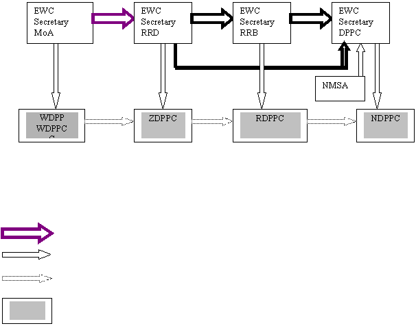
Legend
Main information flow
Information flow to decision-makers
Other information flow
Main decision-making bodies
There are “Early
warning committees” at various levels of government i.e. the Federal DPPC,
Regional Disaster Prevention and Preparedness Bureaus (RDPPBs),
Zonal Disaster Prevention and Preparedness Departments (ZDPPDs)
and the Wereda Early Warning Committee. The
NCEW depends on these committees to collect and analyze information and data
pertaining to weather, crop, food, market trends, commodity prices, livestock
conditions, water and pasture, and food and nutritional conditions.
Since the change
of government in 1991, there has been a genuine attempt by the central
government to decentralize and improve community participation in disaster
response. The 1995 Proclamation has made the regional DPPBs
autonomous because of the federal system of government (EG, 95). For example,
the Wereda Early Warning Committees play
important roles in the dissemination and collection of early warning
information. The DPPC’s baseline socio-economic data
is collected at this level (Hadera 2000). They
also report any climate-related impacts to the government.
Various
government actions were taken to strengthen the national preparedness for
disaster. In 1992, the Ethiopian Transitional Government established the
Emergency Food Security Reserve Administration (EFSRA) to improve its capacity
of disaster response (DPPC 1998a 6-15). The government constructed food stock
silos at various strategic locations so that food could reach the market or the
needy people on a short notice. Ethiopia’s food reserve capacity was raised from
33,000 MT in 1991 to 307,000MT in 1997 (ibid.). The government also
established the National Disaster Prevention and Preparedness Fund (NDPPF) to
cover the financial costs that may arise when climate-related disasters strike.
Donors, the UN, NGOs, and Regional Presidents are the board members of the
NDPPF. Shortage of inputs, such as seeds and oxen are important impediments for
farmers’ responses during drought. Access to oxen and seeds determine the
decision of farmers to replant when variability of rainfall destroys crops.
These inputs are also important for post-drought rehabilitation by farmers.
Agricultural extension services were used to provide inputs.
The Ministry of
Agriculture, which is mandated to oversee the seed banks, plays an important
role in the distribution of inputs to farmers. The sector ministries and the
regional states implement relief-based development projects, such as “food for
work “or” employment generating schemes. The Livestock Preservation Program was
also created to encourage farmers to focus on fodder production and controlled
grazing.
Thus, in
the 1990s, the Ethiopian government has been successful in drafting and in
implementing food security policies. In 1996-97, the various policies of the
Ethiopian government achieved their goal. There was a bumper harvest of about
11 million MT for the first time in Ethiopian history. However, the 1997-98 El Niño induced erratic rainfall, which reversed the trend on
increasing food production.
Climate-related
and other hazards in Ethiopia
There are
many hazards, climate-related and otherwise, in Ethiopia. The most common disasters are droughts,
floods, fires, epidemics, pests and earthquakes. Drought
is the leading climate-related hazard in the country that particularly affects
the food security of the people. Creeping environmental problems, such as soil
erosion and deforestation, are widespread and increase the impact of
climate-related hazards (Addis Zemen Sene 17, 1989 E.C). There is the problem of land
mines due to the civil war and the current conflict with Eritrea that erupted on May
12, 1998.
Level of
scientific research related to El Niño
Preliminary research
is carried out at the National Meteorological Services Agency (NMSA) about the
relationship between Ethiopian weather and El Niño.
An understanding of El Niño as a cause of
climate-related hazards in Ethiopia before the 1997-98 event was limited to
the NMSA and the DPPC. The NMSA began to develop an interest in the long-range
weather forecast and El Niño after the 1983-84 drought that killed about one million people (Kassahun 2000). El Niño forecasts
have been an important aspect of Ethiopia’s response to climate-related hazards
since 1987 (Glantz 1996). According to Kassahun, NMSA’s serious
scientists conducted a discussion regarding the possibility of El Niño’s effect on Ethiopian weather after reading the work
of Marc Cane about the 1982-83 El Niño.
In 1987, a NMSA
report stated that ENSO events negatively affect the rain-producing components
of the Ethiopian weather. The report also stated that the impact of ENSO on
Ethiopian weather is indisputable (NMSA 1987). After the severity of the 1983-84
drought, the NMSA was “compelled to prepare and issue a seasonal forecast of
belg (small rain period) and Kiremt
(big rain period) rains of 1987, well in advance” (Haile
1987a, 54). According to Haile, there is no
theoretically sound methodology for the NMSA to carry out its long-range
weather forecast. The NMSA used the analogue method to forecast the
anomalous seasonal rainfall. Forecasting by analogy is used in an attempt to
know the future in situations where the “cases are analogous to ways that societies
might respond to environmental change” (Jamiesson
1988, 79). The government adequately responded to avert the 1987-88
famine and was awarded the Sasakawa-UNDRO award (Bekele 1997, 112).
The National
Meteorological Services Agency has been using the technique of forecasting by
analogy in its use of El Niño as a drought early
warning. The NMSA agency identifies the current ENSO event and compares
it with similar past ENSO events for which the impact on Ethiopia is known. The idea is to forecast that
the impact on Ethiopia of the coming ENSO event would not be
different from the past event. For example, the 1997-98 El Niño
was compared by NMSA with past El Niños, and it was decided that it
resembled the 1972-73 El Niño. NMSA then concluded
that the impact of the El Niño on the amount and
distribution of rainfall in 1997 would be similar to that of 1972-73.
Similarly, the impact of the current La Niña on the
rainfall amount and distribution of rainfall in the Kiremt
2000 is similar to the analogue year of the 1980 La Niña.
The use of forecasting by analogy to reduce the impact of the anomalous weather
has been very important in Ethiopia’s drought early warning. NMSA
forecasters also take the SST of the Indian and Atlantic oceans into account. Then NMSA forecasts
precipitation by classifying rainfall into normal (75 percent-125 percent of
long term mean rainfall), below normal (less than 75 percent of long-term mean
rainfall) and above normal (more than 125 percent of long term mean rainfall) (Babu 1999b, 68).
Historical
interest in El Niño before the 1997-98 Impact
There was no
mention of El Niño at the popular or media level
before the 1997-98 period, with one exception.
Following the 1982-83 El Niño that led to the 1984
drought in Ethiopia, the NMSA initiated the application of
El Niño information as an early warning for the 1987
drought. According to Kassahun, NMSA experts for the
first time explained the concept of El Niño to the
public on TV on August 5, 1987. Information from the DPPC also reveals
that ENSO information was being incorporated into the early warning system
since then (Teshome 1997).