SETTING :
Country profile
Vietnam
lies on the Eastern Sea, bordering Laos and Cambodia. It has a coastline over
3,000 km in length. The population of Vietnam was estimated at 76.3 million in
1999 and is growing at an average annual rate of less than two per cent.
Vietnam's population density is notable, with 231 persons per square kilometer
on average. The population is predominantly rural. Around one quarter of the
land area is cultivated, with major agricultural centers in the northern and
southern deltas. Close to 30 per cent of the land area is classified as forest
and woodland. Natural resources include limited but productive agricultural
land, deposits of oil, coal, and a variety of mineral resources, hydroelectric
potential, forests and marine resources. There is a considerable, but largely
undeveloped, tourist potential.
Most
of Vietnam has a tropical climate, although subtropical northern areas
experience cool winters. Tropical cyclones frequently make landfall in central
and northern Vietnam and occasionally in the south. It has been argued that the
physical vulnerability of the country and its dependence on delta agriculture
has contributed to a very high level of social cohesion. A history of regular
invasion and colonization has also played a part.
Vietnam
is a Communist state, led by a president, a prime minister, and a cabinet. The
Vietnamese Communist Party is the only legal political party. All citizens may
vote at the age of 18. The national assembly has 395 seats. In 1986, Vietnamese
Communist Party General Secretary Nguyen Van Linh introduced doi moi, a program of economic
renovation, reducing central planning and encouraging private‑sector
enterprise and foreign investment.
Figure 1 - GDP by
sectors
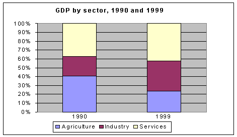
Source: Development and Cooperation Report 2000,
UNDP Vietnam
During
the 1990s, and with the lifting of the US trade embargo, the process of doi moi has resulted in marked economic
growth, surpassing 10 per cent a year during the mid-1990s. According to the
UNDP (1999), prospects for strong and sustainable economic growth are
promising; the country has a low‑cost, highly disciplined and literate
labor force, a diverse natural resource base, and a strategic regional location
for business and trade. Agriculture employs more than half of the labor force.
Vietnam exports a large quantity of rice; other exports include tea and pork.
The contribution of services and industry to GDP is growing.
Despite
recent economic growth, the population of Vietnam remains poor, with an average
GDP per capita of around US$375 per annum in 1999. Nevertheless, Vietnam has
achieved a relatively high level of social development. The UNDP Human
Development Report for 1999 ranks Vietnam 110 out of 174 countries based on a
composite human development index of life expectancy, educational attainment
and income. High life expectancy, a high literacy rate and low infant mortality
are the major factors contributing to this high ranking.
The
development strategy of the Government of Vietnam is people-centered, aiming to
promote the potential of individuals and communities as well as of the nation.
As stated at the World Summit for Social Development in Copenhagen in 1995, the
strategy is for the people and by the people, "... centered on the task of
caring for and developing human potential, which considers human beings as the
key to change, the creative energy, the source of material and spiritual wealth
of a society and, at the same time, a strategy which sees as its highest goal
the well‑being, freedom and happiness of human beings." The strategy
will be underpinned by an enabling environment of sustainable high economic
growth, stability and equity. The current target is that GDP should grow at an
average rate of 7‑8 percent a year and that poverty will be eliminated by
2010.
Government mechanisms
for dealing with climate-related impacts
Because
of the scale of the threat posed by storm and rainwater or seawater flooding
impacts, disaster management in Vietnam has historically focused on these
hazards as they have major impact on societal well-being. Drought
impacts, in this nation of large-scale irrigated agriculture, tend to be more
restricted in scope but are dealt with through the same system as storms and
floods. There is no national mechanism for dealing directly with El Niño, La
Niña or climate variability in general. Section 3.3 contains a full account of
the system for protection against storms, floods and related hazards; here,
administrative responsibilities are summarized. These roles are, to some
extent, historic in nature with certain elements dating back to previous
centuries, though the detail of the current structure was established in the
early 1990s.
The
Prime Minister of the Government has elected the Ministries and Ministry‑level
offices such as Ministry of Agriculture and Rural Development, Ministry of
Science, Technology and Environment, Ministry of Transportation, the Government
Council, Ministry of Fishery, Ministry of Energy, Ministry of Heavy Industry,
National Civil Aviation Agency, Ministry of Defense, etc., and, of the lower
level, Department of Agriculture and Rural Development, Department of Fishery,
and especially Hydro-Meteorology Service, to be responsible for
flood and typhoon prevention in order to protect people and properties.
The
Government has also established the National Flood and Storm Prevention
Committee (also known as the Central Committee for
Flood and Storm Control or the Central Committee for Flood, Storm Control and
Disaster Preparedness) that has ministerial status and is led by the Minister of the
Ministry of Agriculture and Rural Development, which has responsibility to
monitor and control information and data related to flood and typhoon as well
as other adverse climate events, including drought, that may affect people,
properties and production in the whole country. This committee also proposes
the flood and typhoon prevention plans every year as a basis for the allocation
of resources and advises the Government to issue Circular Letters, Regulations,
Instructions, and other legal documents relating to forecasting and preventing
floods and storms. Flood and Storm Prevention Committees exist at the national, city and provincial, and district level and
within relevant ministries. Each commune (village) also has a Flood and Storm
Prevention officer. The Ministry of Agriculture and Rural Development and Ministry of
Fishery and other ministries and institutions have responsibility to instruct
their departments at the provincial level to implement the plans on flood and
storm prevention proposed by the committee.
The
Hydro-Meteorology Service is responsible for
forecasting and consulting the Government and the Ministry about the occurrence
and change of any climate and weather patterns related to the appearance of
floods and storms in the territory of Vietnam.
The
mass media such as television and radio both at the national and local level
have responsibility to release and transmit forecasting information and data
about flood and storm supported by the Hydro-Meteorology
Service.
In 1994, the Government prepared a
Strategy and Action Plan for Mitigating Water Disasters in Vietnam
(MWR/UNDP/UNHDA, 1994) building on the previous disaster management system.
This makes Vietnam one of a handful of countries worldwide to have adopted such
as strategy (Benson, 1997). The strategy is based on the themes: forecasting
and warning, preparedness and mitigation, and emergency relief. The Disaster
Management Unit, established at that time, now supports the operations of the National Flood and Storm
Prevention Committee.
(For further information, see Section 3.3 and references therein.)
The flow of responsibility is shown in the
accompanying chart (Figure 2).
Figure 2 -
Governmental Mechanism dealing with climate related disasters
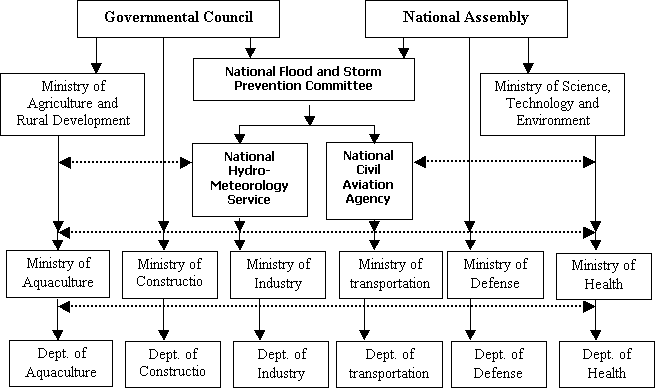
Source: Center
for Environment Research, Education and Development
Climate-related and
other natural hazards affecting Vietnam
Several
kinds of climate-related disasters and other natural hazards affect Vietnam
regularly. An understanding of each type of disaster in order to assess and
forecast them is one of the imperative needs of not only the Vietnamese
Government and authorities but also local communities that disasters affect
each year. The need to cope with natural hazards has played a major role in
Vietnam's history (Kelly et al., in
press), but it has only recently been recognized that El Niño and La Niña
modulate the occurrence of many of these hazards (see Section 1.4).
Major
natural hazards, in rough order of importance, include tropical cyclones,
floods, drought, weather-related hazards such as heat waves and thunderstorms,
pests and diseases and geological hazards. For further information, see DMU
(1999).
Tropical
cyclones (typhoons)
The
tropical cyclone is considered one of the most serious natural hazards
affecting Vietnam. The results of this phenomenon are high winds, heavy rains,
and floods. The geographic scope of cyclones is concentrated in the Eastern
Sea, the Red River Delta and the coastal zone from Quang Ninh to Khanh Hoa provinces.
On average, there
are about 30 tropical cyclones occurring in the Western North Pacific a year,
of which 11‑12 tropical cyclones land in the Eastern Sea, and 6‑7
storms and tropical depressions affect the territory of Vietnam. For Vietnam as
a whole, the cyclone season lasts for about 6 months from June to November
(Figure 3). Cyclone seasons are different in different regions in the country
and occur increasing later from the north to the south. In a particular region,
the cyclone season in each year lasts for 3‑4 months on average. Winds
within a tropical cyclone on the sea can reach speeds of 60m/s, that in coastal
zone about 40‑50m/s, the Red River Delta and coastal area of Mid Central
Vietnam about 30‑40 m/s. Heavy rainfall can reach an amount of 100‑300mm/day
and total rainfall for each spell can reach 500‑1000mm, as happened in
many regions of the eastern Red River Delta, the eastern Truong Son Mountains,
and especially in the northern coastal zone and Mid Central Vietnam.
Figure 3 - Monthly frequency of tropical cyclones in Eastern
Sea
Source: Climate Research Center, Institute of
Meteorology and Hydrology (IMH)
The
seasonal occurrence of storms in the area of the Western North Pacific, in
general, and the Eastern Sea, in particular, as well as their impacts on
Vietnam, are unpredictable. In the years that tropical cyclones have developed
rapidly, the area of the Western North Pacific could have 40 storms. Within the
Eastern Sea, there would be around 10‑15 storms annually in these years.
The least severe year would have a storm rate of 40‑50% in comparison to
the average level, even less than 40%. There were 12 storms making landfall in
Vietnam in the most severe years, such as 1964. The least severe year was 1976.
This clearly complicates disaster management and the allocation of resources on
the seasonal timescale. As Section 2.3 indicates, El Niño plays a major role in
affecting cyclone characteristics, and a predictive capacity based on the El
Niño Southern Oscillation (ENSO) phenomenon would be of substantial value in
improving disaster management.
The
losses associated with tropical cyclones or typhoons are generated by damage to
infrastructure, boats and plantations, etc. on the continent, the sea and the
islands. Heavy rain can create floods in various areas, especially in the
coastal zones and the Red River Delta. Heavy rain created by typhoons can also
cause flash floods and landslides in the mountains of Northeast and Central
Vietnam. The consequences are severe, causing loss of the workforce and
property. Severe Tropical Storm Linda in 1997, for instance, caused 4,000 dead,
wounded and missing people and the loss of property was estimated at thousands
of billions of VND.
Short‑term
sea level rise and storm surges damage property in the coastal zone. Longer‑term
sea level rise caused by climate change may also be contributing. In the
coastal zone of Central Vietnam, the sea level rise in a storm can reach a
level of 3‑4 meters, especially at high tide. In the coastal zone of the
North, sea level rise in a storm is lower than 2‑3 meters. Sea level rise
and the associated storm surge have destroyed construction works, especially
the sea dyke system, coastal cultivated areas such as agricultural fields, salt
fields, mangrove forests and have also caused landslides in coastal areas. The
Mekong Delta and Red River Delta are affected regions.
Floods
Floods
are usually caused by heavy rain lasting for a long time and over a broad area.
The ability to keep water in the forests is increasingly reduced by illegal
logging activities. Heavy rains are the result not only of typhoons but also
from other disturbances such as weaker tropical storms and fronts, both
contributing to floods. Especially when there is a combination of these
factors, severe floods can be created. The increase in the Walker Circulation
in the La Niña process also contributes to a high frequency and density of
heavy rains in downstream areas of the rivers. Continuous floods in the Central
region of Vietnam are certain examples of this process.
Floods
may happen in almost all areas of the country but the losses mostly occur in
the downstream areas of the basins. In the Red River Delta, the flood season is
almost the same as the rainy season, but it starts one month later. The flood
season extends from June to November every year and the most serious period is
in the period from August to November, created within the Red River Delta and
Thai Binh catchment. The Red River Delta, in which is located not only the
capital city of Hanoi but also many important cities, is protected by an earth
dyke system that has a length of thousands of kilometers. The flood season in
the basin usually creates high stress on the dyke system. Some dykes have been
broken by strong floodwaters, creating serious flooding through some regions
within the Red River Delta.
In
the Mekong Delta, the flood season has similar characteristics to that of the
Red River Delta, but it occurs later. The broad catchment creates a high
intensity of floods flowing to the downstream regions. With no dyke system to
protect the crops, there can be no planting in the last season. At the current
time, irrigation activities, especially drainage systems, have been developing
day by day to allow the expansion of extensive crops and to increase the number
of crops annually. However, flood is still a serious consideration for millions
of rural people in the Delta.
In
the coastal provinces in Central Vietnam, the river systems are short with high
slopes so that floods can rapidly reach downstream areas where the forest has
been destroyed. In the East side of the Truong Son mountains, especially the
area of Northern and central zone of Central Vietnam, heavy bands of showers
lasting for a long time create the most serious floods in the territory and in
urban areas near the coast.
In
the mountainous areas, as a consequence of illegal logging in combination with
rainy seasons with a high frequency of heavy rains, there recently have been
marked climatic turbulences such as tropical cyclones, cold fronts, etc.
causing serious flash floods in many areas, such as those in Lai Chau and Son
La provinces in the years of 1995‑1996. Thus, flash floods have been
taking place sweeping water and sludge down from the mountains and creating
landslides and other disturbances in transportation, villages, rice fields, and
irrigation works. Landslides in the downstream areas of the Red River Delta and
the Mekong River Delta are closely related to floods, also showing a rapid
increase in recent times. Annual improvements of the dyke system for flood
prevention account for a large part of the budget of both the nation and local
regions.
Drought
Drought
is a climate phenomenon that occurs in many areas. A meteorological drought
takes place in an area that goes without rain for a long time, along with high
temperatures. Hot weather created by the effects of the southwest monsoon is
the main reason for drought in various areas. However, drought can occur over a
broad area because of monsoon failure. El Niño is also one of the reasons that
droughts occur. In El Niño years, due to an associated late summer monsoon, the
rainy season may be postponed, causing a longer dry season with strong summer
sunlight and drought because of the combination of these factors at the
beginning of the rainy season. Drought can also occur in the middle of a rainy
season, when it is rainless for an extended period of time in combination with
high radiation and high temperatures in the summer. Cloudless weather also
increases evapotranspiration, causing partial drought in a broad area of the
South, Southern plateau, central coastal zone, and sometimes in the north.
Drought
can occur in every part of Vietnam. In recent years, drought has often occurred
in Central Vietnam and in the Central Highlands. Drought has caused loss of
agriculture productivity and production as well as irrigation problems.
Forestry, the power industry, and water supply for domestic and industrial uses
are the victims of droughts' impacts. Drought in the Southern plateau in 1997‑1998
caused thousands of coffee farms to be damaged or lost. Drought caused a
waterless situation for the whole of the Quang Binh and Quang Tri provinces in
the years 1993‑1994 and 1997‑1998. In the El Niño episode of 1997‑1998,
drought caused serious forest fires in the Southern plateau and the Mekong
Delta with dozens of thousands of hectares of cajaput and pine forests damaged. At the same time, a decrease in
rainfall in the Red River Delta in the North also caused a low water level of
the Hoa Binh reservoir that directly reduced power generation affecting many
provinces, including Hanoi Capital.
Other
weather-related hazards
Frost
and hoarfrost are climate disturbances that happen mostly in the North,
especially the mountain areas, caused by the Northeast Monsoon. The impacts of
polar airmass effects on countries in the low latitudes of the Inter-Tropical
Convergence Zone (ITCZ) such as Vietnam are abnormal phenomena for this
climatic zone. However, in comparison to the high latitude areas, the
temperature drop is not so low, and is some degrees lower than 0oC
in the mountainous areas. But for people who are adapted to higher temperatures,
temperatures lower than 10°C can create negative reactions, affecting normal
health and well‑being. If this lasts for an extended period of time, the
effects can be remarkably more serious.
A
continuous Northwest Monsoon flow in the winter can decrease temperatures to
below 5°C, and in combination with hoarfrost, can cause serious damage to
tropical ecosystems because of their poor ability to adapt to low temperatures.
In hoarfrost weather, whole rows of plants have died because of the freezing of
plant tissues. Many plant species, especially tropical plants, have died when
temperatures have fallen lower than 5oC. Rice, the main food plant
of Vietnam, is affected seriously when temperatures drop below 13oC.
In weather forecast reports, it is called “hazardous cold.” In the north,
hazardous cold usually occurs in the middle of winter, especially when
Northwest monsoon comes, as the winter rice crop is mature causing low
productivity. It is considered a remarkable hazard in Vietnamese agricultural
activities.
For
human health, particularly when it involves people accustomed to the hot
weather of a tropical area, the adverse effects can be serious. Cold weather in
the last half of winter in the North of Vietnam accompanied by high humidity
and drizzling rain can have even greater negative impacts on human health and
livelihoods. The cost of cold prevention (crop protection) increases in years
of cold weather.
In
the area suffering the impacts of weather fronts associated with the Southwest
Monsoon and the high altitude of the Truong Son mountains as well as the area
of Lao‑Viet in the northwest, hot and dry periods take place in the
summer. This is called the Lao Wind
because it comes from Laos. Hot and dry phases usually occur in the development
phase of the summer monsoon. In the northwest, the Lao Wind first comes from
March to April, when the influence from the west is increasing in place of the
Northeast Monsoon from the east. In the central coastal zone, the front occurs
later, from May to June, but lasts until August and September. This phenomenon
interrupts the rainy season on the east side of the Truong Son Mountains. In
combination with tropical cyclones and the Northwest Monsoon, this phenomenon
causes a unique change in the rainy season to the east that is different from
the north and the south. When the western monsoon develops on the north, hot
and dry weather occurs not only in the northwest and northern central region
but also in the northern coastal zone.
Along
with a hot and dry climate caused by fronts, there are many long‑lasting
periods of hot weather derived from different sources, such as a domination of
high tropical pressure or the western current of the Walker Circulation. In
these cases, cloudless weather and high radiation will occur causing a rainless
period and high temperatures for a long time, sometimes seriously affecting
many areas. Hydrological drought, a lack of water in combination with high
temperature and evaporation, not only affects crops but also human health. In
the years when the Lao wind arrives early, the productivity of the winter crop
will decrease considerably creating disaster for the rice crop (and farmers) of
North and Central Vietnam.
Thunderstorms
develop within the hot, wet climate of the tropical atmosphere, especially when
there is a combination of disturbances such as polar fronts and tropical
cyclones. A thunderstorm can create an electric discharge in the atmosphere or
between cloud and the ground, thus lightning. Vietnam is an area with some of
the most severe storms. In Vietnam, thunderstorms develop during the summer
monsoon with the existence of a hot and humid air mass and a stable atmospheric
structure. In the North, thunderstorms occur all the time. They also develop in
the mountainous area of the North and midland of the South. In the central
area, thunderstorms can occur on 130‑150 days in a year. In the coastal
zone, the period with the occurrence of thunderstorms is much reduced, to about
40‑60 days. It is especially
reduced in the area of Southern Central region where it is much lower, only
about 20‑30 days.
Lightning
can damage many technical targets, especially electric and electronic
equipment. It also kills people in many areas. Lightning prevention for
electric and electronic equipment, especially outdoor equipment, is one of the
imperative needs in Vietnam with very high cost. A thunderstorm can also create
whirlwinds and waterspouts. Although whirlwinds occur in a restricted area, the
velocity is high causing much damage to infrastructure, construction works,
plantations, etc. In the sea, large lakes and rivers, whirlwinds cause
considerable damage to boats and people.
Thunderstorms
and whirlwinds can occur in many part of the Vietnamese territory. The higher
the level of economic development, the greater the loss due to whirlwind and
thunderstorm damage.
Diseases
and pests
The
hot and humid climate of tropical areas causes many kinds of human and animal
diseases. Many epidemic diseases associated with climate such as malaria,
dengue fever, flu, diarrhea, etc. have been on the increase in many provinces.
This has cost the Government increasing amounts of money for both cures and
prevention. A dengue fever epidemic has been spreading in Vietnam and is
considered an El Niño-related disease. Malaria is tending to increase in many
mountainous areas. Flu occurs regularly every year, especially in the periods
of transition of the seasons.
In
agriculture, aquaculture, and forestry, pests have become a very serious
problem causing considerable decreases in the productivity of farming and
breeding. Vietnam is a suitable environment for pest vectors and for their
spreading over a large area and damaging crops, animal breeding activities, and
aquaculture. Pests are a hazard every year for many regions all over the
country. El Niño events have been
associated with the increase in occurrence of various pests. The same is true for La Niña episodes as well.
Earthquake,
depression, cracking and landslides caused by geological activities
Earthquakes
in Vietnam’s mountainous areas can reach 4‑5 on the Richter Scale, but no
major damage has been experienced because they tend to be centered far from
urban and residential areas. Depression, cracking and landslides caused by
geological activities have recently been taking place, but have presented no
serious danger to people or construction works.
1.4 Level
of scientific research in Vietnam relating to El Niño
The El Niño phenomenon has been covered in
scientific studies in Vietnam for two decades or more but it is only recently
that a concerted scientific effort has been made to study the subject. The
introduction of El Niño into scientific studies in Vietnam was initiated in the
early 1980s by the Institute of Meteorology and Hydrology by Professor Vu Boi
Kiem. There was, though, a lack of information and knowledge about this issue
so that it did not attract scientific interest. Thus, the study of the phenomenon was neglected and was not often
mentioned in meteorological and hydrological studies in Vietnam. Two papers on
the ENSO phenomenon were prepared towards the end of the 1980s by Hoang Minh
Hien and Nguyen Huu Ninh (Hoang Minh Hien
and Nguyen Huu Ninh, 1987, 1990).
The situation changed in the early 1990s
with the assistance of UNEP and Dr. Michael Glantz. In November 1991 at the 'International Conference on the Impact of
Climate Change and Sea Level Rise' in Hanoi, organized by the Center for
Environment Research, Education and Development (CERED) with support from UNEP,
some reports on El Niño presented by international experts attracted the
attention of the Vietnamese scientific community to the subject again.
During the 1990s, much research on
ENSO-related hazards such as the tropical cyclone, flood and drought was being
conducted by various agencies, as had occurred for many years, but these were
regarded as single events unrelated to any longer-term or larger-scale process.
Knowledge of ENSO itself was acquired and updated mainly from international
sources (such as Bjerknes, 1969; Ramage
and Hori, 1981; Philander, 1990; Allan, 1991; Glantz, 1991).
By the late 1990s, largely stimulated by
the 1997-98 event, scientific studies by Vietnamese scientists had begun on
various relationships with climate and weather in Vietnam (see, for example, Biu Minh Tang, 1998, 1999; Dang Tran Duy, 1998,
1999; Hoang Minh Hien, 1998; Nguyen Doan Tho, 1998; Nguyen Viet Pho, 1998;
Nguyen Viet Thi, 1998; Pham Duc Thi, 1998, 1999; Le Dinh Quang, 1999; Tran Viet
Lien, 1999). Updating and applying data and information from ENSO forecasts
carried out by forecast groups all over the world is also underway within
relevant hydro‑meteorological sectors. Studies associated with socio‑economic
issues, including fisheries, forestry, and agriculture, have been implemented
by Vietnamese researchers. For example, according to the announcement of
National Oceanic and Atmospheric Administration (NOAA) Office of Global
Programs (OGP) in January 1999, the Center for Environment Research, Education
and Development (CERED) has been involved in forecasting the risk of dengue
fever epidemics in the Asia‑Pacific Region (Tran Viet Lien, 1999).
Now that it has been recognized that
assessment and forecast of the impact of ENSO is an important need for the
national management authorities in Vietnam, in the period 1999‑2000 the
Government has organized an independent study on ENSO. The Institute of
Meteorology and Hydrology is the executive agency. The Hydro-Meteorology
Service, the Ministry of Agriculture and Rural Development, and the National
Center have commissioned several sectoral studies on climatic disasters and
ENSO for Natural Science and Technology. In addition, proposals have been put
forward for national studies as part of international initiatives such as those
supported by U.S. NOAA.
A workshop on "The Impact of El Niño and La Niña on Southeast Asia" was
organized by the Center for Environment Research, Education and Development on
behalf of the Indochina Global Change Network.
It was held in Hanoi, Vietnam in February 2000 with support from the
Asia Pacific Network for Global Change Research. The workshop participants
advanced a series of detailed recommendations regarding practical action that
should be taken promptly to strengthen the region's capacity to respond
effectively to El Niño and La Niña events, including the greater involvement of
the region's scientists (Kelly et al.,
2000). They strongly endorsed moves towards a proactive response to such
hazards. For further information on the workshop, see http://www.cru.uea.ac.uk/tiempo/floor0/briefing/igcn/igcn2000.htm
Historical interest
in El Nino before the onset of the forecast and/or impact of the 1997-98 event
The
first popular article on El Niño was written by Dr. Nguyen Huu Ninh and Dr.
Hoang Minh Hien and released by The People newspaper on 21 June 1987 (see Box 1). However, at that time, El
Niño and La Niña were not of concern in Vietnam because their impacts had not been
clearly shown. As noted in the previous section,
scientific organizations, especially hydro‑meteorology and climate study
institutions, had noticed and studied El Niño before 1997 but political
organizations and policymakers, as well as public institutions and the people,
had very little information regarding what El Niño was or even awareness of it
as a factor underlying the country’s natural hazards.
Box 1. The first article in Vietnamese written
on El Niño by Nguyen Huu Ninh and
Hoang Minh Hien, released by The People on June 21, 1987